Fourth Snowiest March on Record
By Russell Russ
March was a month full of nor’easters. The brief warm up in February fooled everyone into thinking winter was over and spring was here. March relentlessly brought us all back into reality. The first day of March was warm, the warmest day of the month actually, but it was back to winter after that. From March 2 to March 22 the weather talk was all about current and pending nor’easter storms hitting New England. Thanks to February’s late month warmth, most local lakes and ponds were ice free as of March 1 and basically stayed that way to close the winter season despite March’s cool and snowy weather.
March’s high temperature of 53 degrees was observed on March 1 and the low of 8 degrees was observed on March 18 and 20. With an average mean temperature of 30.2 degrees, it was just 0.5 degree below normal. Temperature-wise it was a very normal March and there were no daily or monthly records set.
The total precipitation for the month was 4.02 inches, 0.41 inch below normal. Through the first quarter of 2018 the total precipitation amount was 14.99 inches, 2.92 inches above normal. Precipitation this month was mostly in the form of snow. In weather observing all snowfall is melted then measured as a liquid and is included in the total precipitation amount.
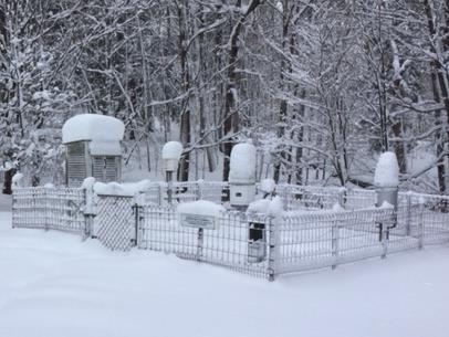
Snow was the story this month. The March 2-3 storm started as rain and then finished with 5 inches of snowfall. The March 7-8 storm was the big one, it gave us a total snowfall of 22.2 inches. The March 13-15 storm produced a total snowfall of 15.3 inches. On March 15 there was 26 inches of snow on the ground. The last storm was to hit March 21-22, but it stayed to our south giving Long Island large amounts of snow. Norfolk got just 0.8 inch from that one. That final nor’easter proved to be very difficult to forecast and many local meteorologists missed the call on it and took much heat from the public for their forecast failure. Observing and recording the weather is much easier than forecasting it.
March’s snowfall total of 43.5 inches was 26 inches above normal and ranks it as Norfolk’s fourth snowiest March over the last 87 years. We had a decent chance to come in second, but the failed March 21-22 storm stopped that. The snowiest March was in 1956 when Norfolk recorded a whopping 73.6 inches. The other top snowy Marches were 1967 with 46.5 and 1958 with 45.6 inches. Through the first quarter of 2018 the total snowfall amount was 80.2 inches, 21.2 inches above normal.
The 2017-18 winter season (October-March) snowfall total was 96.6 inches. This was 13.1 inches above normal and we still have April and May to officially close out the winter season.
Will April bring springtime to Norfolk? Not a chance, at least for the first three weeks of the month. Through April 22, temperatures were running nearly 8 degrees colder than normal and the monthly snowfall total of 10.9 inches was 5 inches above normal. Our winter season snowfall total rose to 107.5 inches, 18.1 inches above normal. Getting snow in April is not unusual, what was unusual; what was unusual was the regularity of snow or sleet. Of the first 19 days of the month, there were 12 days with either snow or sleet falling. It was endless winter and everyone was longing for springtime.
The good news is that the tide mostly turned by April 21 and warmer weather and no snow was in the immediate forecast. Let’s hope this forecast is accurate. Even though it was late in arriving this year, spring will be much welcomed by everyone. It has been a long winter.