
PREVIOUS WEATHER REPORTS

Balancing Tradition and Change with Maple Syrup Veteran Jody Bronson
Maple syruping is as synonymous with New England as Dunkin’ or the Patriots, but with much more history. Far from an heirloom, it’s a living, breathing practice, with sap-obsessed devotees across the region trudging through deep snow each year at the first hint of warmth in the hopes of a good yield.
GMF Forester Emeritus Jody Bronson is one such acolyte, and as he’ll tell you, turning sap to syrup is serious business – “You either go into it all the way or don’t do it at all.”
Bronson, with a lifetime of sap boiling under his belt, has helped keep the traditional spirit of syruping alive at GMF. Like many historic practices and customs that have survived, maple syrup production is suspended in the balance between old knowledge and new technology as the world – and climate – changes around it.
Bronson stepped back from his duties as GMF’s lead boiler this year, nearly fifty years after first joining GMF’s syruping team. Read on below for Bronson’s reflections on his own history with GMF’s staple forest product.

While many saphouses have turned to oil or propane to fuel operations, GMF still uses locally harvested wood. Photo: Jody Bronson
Sap season and climate change
Spring, while exalted for the colorful profusion of blossoms and greenery in its latter stage, is a highly phased season. There is the dreaded mud season, of course, the bane of many a hiker and low-clearance vehicle alike. But to those in the know, spring truly begins with sap season, when daytime temperatures climb above freezing and overnight lows remain cold.
As the climate warms, though, this window is getting shorter and coming earlier, which generally translates to a lower sap yield. Speaking on a late February day when the GMF crew was out tapping trees, Bronson said in the “old days” they would manage about 19 collections – days when the sap conditions align enough that sap flows and the team can harvest it – per season, but now they’re down to 12 or so.
Bronson had been out just days before with GMF Forester Kate Regan-Loomis and GMF Property Manager Russell Russ packing trails in the deep snow to make accessing the sugarbush easier. Bronson is efficient in the snowy forest – “Kate and Russell, they go, ‘Jody, you’re fast on snow shoes!’ And I’m laughing because I’m not fast at anything!
“I’ve been on snowshoes my whole life,” he eventually ceded. Still, snowy tapping sessions are growing infrequent as February snowpack becomes less reliable.
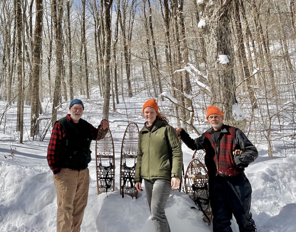
From left: Bronson, Forester Kate Regan-Loomis and Property Manager Russell Russ pack access trails to the sugarbush through deep snow in late February 2026. Photo: Kate Regan-Loomis.
A layer of snow on the forest floor is important in insulating the trees’ roots by delaying buds from sprouting. When buds are out, the sap collection season, which historically ran from late February into April, is essentially over. This winter, which Bronson described as an “old school Norfolk/Falls Village winter,” may bring collections back up, he said, but cautioned that the sap season is a fickle and unpredictable beast.
“When somebody says, ‘Well, how do you think the season is going to be?’ I always say I’ll tell you at the end of April,” Bronson said.
Tuning in to the season
Bronson’s sap wisdom is borne from a lifetime of experience. He grew up in Winchester Center, and started working at a small sugar house when he was nine or ten years old. He was mostly collecting sap in those early days, but he also got his first taste of boiling there. It was love at first sight, or perhaps, first scent, recalls Bronson. “You just love the smell of it.”
He joined the GMF team in 1976, and hasn’t missed a sap season since. Bronson also runs a syrup operation at home with his wife, whose own family in Quebec has deep roots in the tradition. His two daughters also know the trade and lend a hand at the sugarhouse when able. “It’s kind of a Bronson thing,” he said.
Bronson said that the process, which can be grueling, is more than just making a product – it’s a way to get in tune with the transition of seasons. “You’re outside, and noticing all the little details – the little changes,” he said. “It’s the promise of spring, the promise of everything starting to grow again and turn green.”

Local woodsman Wayne Jenkins played a key role in GMF’s syrup production from the mid 1960s to the mid 2000s. Photo: GMF Archives.
Keeping record
It’s the observational, meditative nature of collecting, boiling, and evaporating sap – and the process’s inextricable link to weather – that motivated GMF foresters in the 1940s to start keeping records, affectionately known by staff as the “Sap Journals.”
The journals are a log of the yield of each day of sap collection each season, as well as, crucially, the conditions that allowed – or didn’t allow – things to flow.
GMF forester Darrell Russ, who ran the GMF weather station for decades, was the first to build out the detailed reports, which Bronson largely took over in the 1990s.

Darrell Russ, longtime lead boiler at the GMF saphouse, tending to the evaporator. Photo: GMF Archives.
The resulting entries are snapshots of sap seasons of yore. One report from March 21, 1956 reads: “Cold & very snowy period. During past two weeks 54” (4 ½ feet) of snow have fallen! Temperature frequently below zero. Mar. 21 a.m. temp. 13. 3 ½ to 4 feet of snow on the level, collecting very difficult.”
Continued cold and snow delayed collection that season, but several weeks later, on April 10: “Perfect day, no wind, bright sun; temp. 45 after a good freeze 25. Deep snow; 1620 buckets, Record Run.”
Bronson maintains that while these records are useful in trying to piece together patterns from the chaos of sap season, they serve a further purpose in memorializing the days when syrup production was a more intimate, hands-on process.
“This is where I think all these old journal records are going to be important,” he said. “People just aren’t doing it that way anymore.”
The old and the new
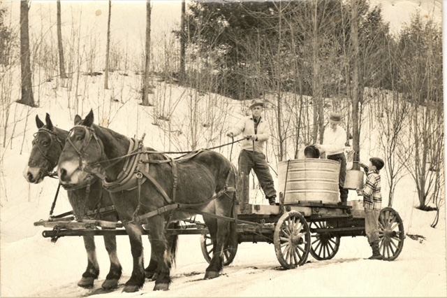
Darrell Russ drives a team of horses as collectors pour buckets full of sap into a holding tank. Photo: GMF Archives.
Like many other industries, sap production is becoming increasingly automated. While sap makers once collected buckets hung on trees, sap now pours directly from the tap into a tube network that deposits the tree’s lifeblood directly into a storage tank. Some systems use vacuum to draw more sap to offset low harvests when nonideal conditions limit sap flow. Less time in the forest means less time to see the details of the changing season, Bronson said, as well as a more distant relationship with the trees themselves.
New evaporators are enclosed to collect steam for pre-heating the syrup, and reverse osmosis units — GMF had one of the original models back in the 1970s — have drastically improved syrup production efficiency. Before newer technology, boilers had to test the syrup with a hydrometer to gauge when it was ready, but that process is now automatic.

Bronson tests syrup density with a hydrometer. While modern equipment gauges when the syrup is ready automatically, syrup makers still run hydrometer tests daily to ensure the machine is accurate. Photo: Holly Jenkins.
“I definitely prefer the old traditional way,” Bronson said. “You can see the boil, you can smell the boil… you have to use all your senses to run an [old] evaporator.”
That’s where the value of the Sap Journals lies, he said – in keeping the old spirit of the work alive.
Still, he recognizes the value of new, efficient technology as the sap season becomes more unreliable. “Global warming has made the window for making syrup shorter,” he said, and new technologies allow syrup producers to maintain their craft. Reverse osmosis units, for instance, have allowed red maples, a much more common tree than the sugar maple in southern New England, to be used for syrup.
As Bronson will tell you, in maple syrup the only constant is change. True to that idiom is the changing of hands at the GMF saphouse after three and a half decades under his leadership. While he admits it’s difficult to cede his duties, he’s confident that the future of maple syrup at GMF is bright under the stewardship of Russell Russ, the son of Bronson’s own predecessor, alongside Regan-Loomis. Plus, he won’t be far in case a helping hand is needed.
“I’m passing it on to good hands,” assured Bronson.
What Happens When We Lose the American Beech?
Less than a decade ago, beech leaf disease was unknown to New England’s expansive beech canopies.
But now? “In Connecticut, every single beech tree has beech leaf disease,” said Elisabeth Ward, a forest ecologist with the Connecticut Agricultural Experiment Station (CAES).
Ward is one of several researchers working on a long-term study in Great Mountain Forest – and across Connecticut – to gather data on this rapidly spreading pestilence in order to forecast what might happen to New England’s woodlands if – or rather when – the beeches are gone.
“This project isn’t about preserving existing beech,” said GMF Forester Kate Regan-Loomis, who helps coordinate and support research projects in the forest. “The question is how is the forest going to respond to beech leaf disease?”
“What is going to come back when the beech are gone? And how does our management affect that?”
Beech leaf disease, often referred to as BLD, was first detected in Ohio in 2012 and jumped to Connecticut in 2019. Caused by an invasive nematode – a microscopic worm – the disease infects the leaves, causing a noticeable “banding” effect, then crinkling the leaves as the disease progresses, ultimately defoliating the tree. Without leaves, the trees cannot photosynthesize, which means they cannot grow and will eventually die.
Ward, who coordinates Connecticut’s forest health program, a joint effort between the Agricultural Experiment Station and the Department of Energy and Environmental Protection, said that BLD is an invasive disease that stands out even in New England’s increasingly-diseased woodlands.
“The northeastern U.S. has a long history with lots of different introductions of forest pest pathogens and diseases from around the world… but an invasive foliar nematode is not something we’ve seen before,” she explained. “Foliar” means that the pest targets the leaf.
“It’s just not something that’s ever been dealt with in terms of a forest health issue.”
This fact, along with the unprecedented speed with which the disease spreads, means that “scientific research hasn’t really been able to keep up with what to do,” Ward said.
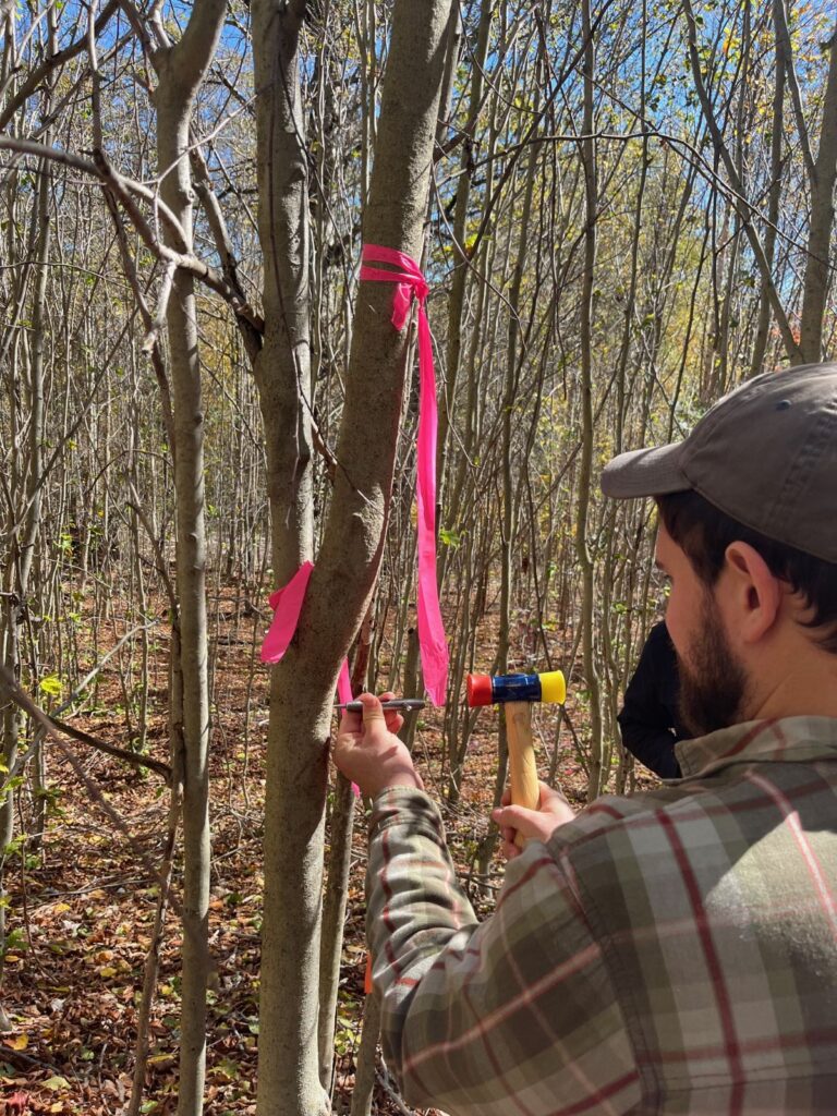
Ward’s own work on BLD seeks to fill the gap formed between the disease’s swift takeover of northeastern forests and the relative lag of peer-reviewed scientific research. She is part of a collaborative, multi-discipline study using eight sets of large forest plots across Connecticut, including some nearly 70 year-old plots within GMF, to examine how beech trees of various age, size, and other variables are responding to the disease.
“We’re calling it a rapid assessment,” she explained, noting that the goal is to survey a large sample size “to get some really robust, good initial data about beech leaf disease and its impacts.”
Her work continues that of Jeffrey Ward (no relation), former chief scientist at CAES and GMF trustee, who began monitoring the GMF plots specifically for BLD when it landed in Connecticut. The project, which is ongoing, tracks 2,500 trees across the research sites, and so far, the scientists have found “pretty much complete stagnation of growth amongst all tree size classes,” she reported.
Interestingly, the researchers have not found a notable uptick in mortality in beech yet, but Ward warned that this isn’t cause to rejoice. Beech are clonal, meaning that in a stand, many stems are connected to the same root system. This enables healthier, larger trees to subsidize sicker ones for a time. When this reservoir runs out, though, possibly due to a co-stressor such as drought, “we’re going to see stand level die back,” Ward said.
While the situation is dire, Ward emphasized that much is still unknown. “We’re kind of limited by our lifetimes and what we see happening,” she said, noting that in Japan, where the nematode is suspected to have originated, beech have “completely co-evolved” with the nematode and live alongside it.
Regan-Loomis said that forest management can help play a role in giving the species a chance at survival: “Evolution is just luck… we can try to direct that in selecting management trees [to protect] that we hope have a good shot.”
Ward is working with GMF to explore another project that would test a potential treatment that could help preserve a sampling of healthier beech trees. Over the summer, she plans to test a phosphite bark spray at sites across the state including GMF. While not a landscape-scale solution – “I wouldn’t recommend spraying anything over the entire eastern United States” – it could save some trees, which is important, Ward explained:
“At least we’ll be doing something to preserve some beech genetic diversity across Connecticut rather than just waiting for them all to die.”
Other researchers are tackling BLD from other angles at GMF. Ecosystem ecologist Jonathan Gewirtzman, who just defended his PhD thesis at the Yale School of the Environment and is moving on to a post-doc at Stanford University, is part of the same collaborative, state-wide project that Ward is working on, but his focus is on what’s happening below the bark.
Researcher Jonathan Gewirtzman takes a core from a small beech to search for nutrient uptake. Photo by Kate Regan-Loomis
Gewirtzman studies non-structural carbohydrates – sugars and starches – in the outer part of infected beech trunks. In other words, he researches tree food. “Do these trees run out of sugar and die? Is that what’s going to lead to their mortality?”
He explained that his lab takes samples twice a year to get maximum and minimums, as trees build up stores throughout the leaf season to sustain them over the winter – “like a hibernating bear.” The research group expects results from the first batch of samples within the next several months.
Another upcoming project comes from Akshay Patel, a first-year Master’s student at the Yale School of the Environment. Patel is currently in the planning stages of a study on whether the disease can be accurately monitored using drone technology.
“In a lot of my research,” he said, “I’ve seen that a common pattern of diseases that run away from us is that we’re not able to keep a consistent and spatially explicit record of where they are.” He explained that more efficient tracking of the disease’s progress will aid forest managers and researchers in myriad ways as the scientific community deepens its understanding of this devastating pathogen.
Despite hints of progress, the story of New England’s beech trees is a sad one, and not just for humans, Regan-Loomis said. She noted that while the tree has often been regarded as a nuisance and of low-value among foresters, it provides vital nutrition for wildlife. “Beech nuts are important especially where there aren’t oak trees around,” she said. “It’s just a very useful, very fatty food for, like, everything, especially larger animals like deer and bear.”
“I always want to defend the beech,” emphasized Loomis.
Following the Forest GMF Style
Great Mountain Forest’s 6,300-acre expanse is, in a sense, one of Connecticut’s broadest highways. Save the rare maintenance vehicle or Sunday stroller, though, it is no conduit for humans, but rather the fast lane – or a rest stop – for the abundant flora and fauna of the New England woodlands.
That highway is not isolated to Norfolk and Falls Village. It is part of an ecological interstate that runs from the uplands of the lower Hudson Valley to the northern forests of Quebec. The Follow the Forest initiative, a collective effort between the Housatonic Valley Association, the Litchfield Hills Greenprint Collaborative, and many other regional groups, seeks to connect and protect this dark green thoroughfare, and GMF is a vital junction on a route that carries moose, bears, bobcats, salamanders, seed pods and beyond across an increasingly fragmented landscape.
The project recently received $30,000 in grant funding to further its mission, which combines citizen science, expert input, and regional partnerships to aid in wildlife mobility along a “corridor” that follows protected forests from the Hudson Highlands through the Berkshire and Taconic ranges before connecting with the Adirondack and Green Mountains and ultimately Canada.
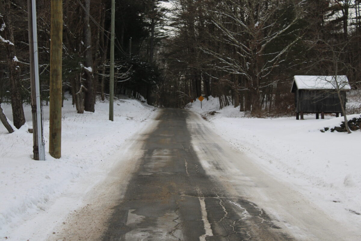
Windrow Road approaching the GMF Visitor Center in early December. Even quiet roads like this can pose an obstruction to wildlife mobility between large forest cores. Photo by Alec Linden.
“Connectivity” is the concept of keeping “core” habitats bridged through “linkages” – sites where animals are able to traverse an anthropogenic boundary from one core to another. Many animals depend on mobility for vital reasons, such as seeking food or water or mating and reproduction, but the isolation of habitats from one another impacts humans downstream as well. According to the World Wildlife Fund, habitat fragmentation stemming from development has impacts beyond local ecosystem collapse, including degrading soil health and polluting fresh water.
Large and connected refuges of wildland that enable animals and plants to move freely are considered havens of “resilience” amid increasing pressures from climate change and development, which is an ecosystem’s ability to survive and thrive amidst disturbance. The corridor that runs up the highland spine from southern New York state to Canada connects an extensive swath of North America’s eastern woods, regarded to be the largest stretch of intact temperate mixed and deciduous forest in the world, according to Follow the Forest.
GMF’s territory makes up what the Follow the Forest initiative identifies as “core forest habitat” – a tract of protected woodland, 250 acres or greater, that is not disrupted by human alterations like roads or farmland. In addition to GMF’s conserved lands, thousands more acres of protected state-owned highland forest spread across the Canaan Mountain massif. Far exceeding the size qualification, the extensive, contiguous, and diverse forest contained within and directly abutting GMF’s boundaries is part of a “key stronghold” of climate resilience, according to HVA Conservation Director Julia Rogers.
During a recent interview, Rogers addressed the value in GMF’s longstanding commitment to conserving forestland. “Without that legacy,” she said, “I would predict that there is a strong likelihood that parts of [the forest] would be developed and we would have a much smaller core forest.”
Big cores, she explained, are fundamental as they are able to withstand disruption and damage more so than smaller tracts of land. “Larger cores are going to be more resilient to all the impacts of climate change,” she said, including more extreme and unpredictable weather patterns, which may topple trees that have less protection.
Plus, GMF has elevation on its side: “As we think about species who are going to need to move either north or upward in elevation as a response to climate change, Great Mountain Forest is going to serve as a key climate refuge.”
“That connectivity with the protected lands further south and lower in elevation is so critical to Great Mountain Forest serving as a key part of the Follow the Forest initiative,” Rogers added.
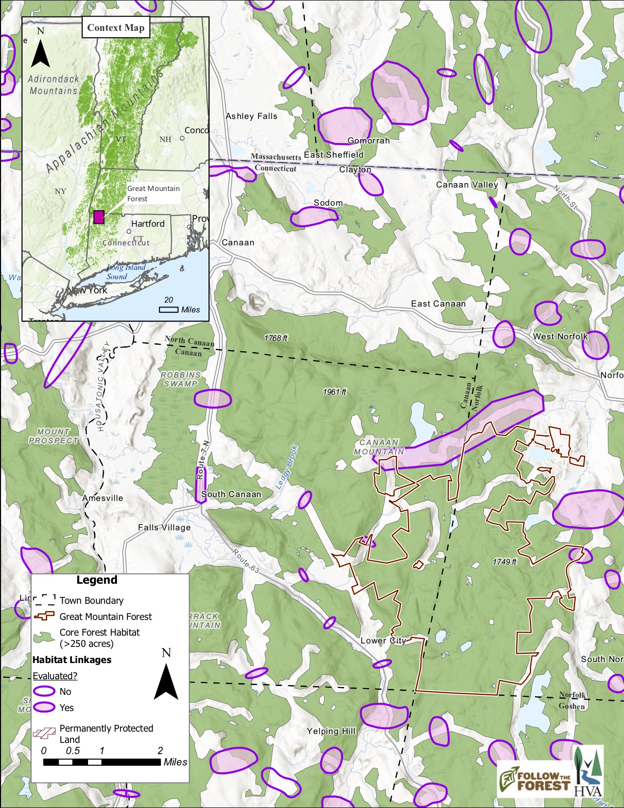
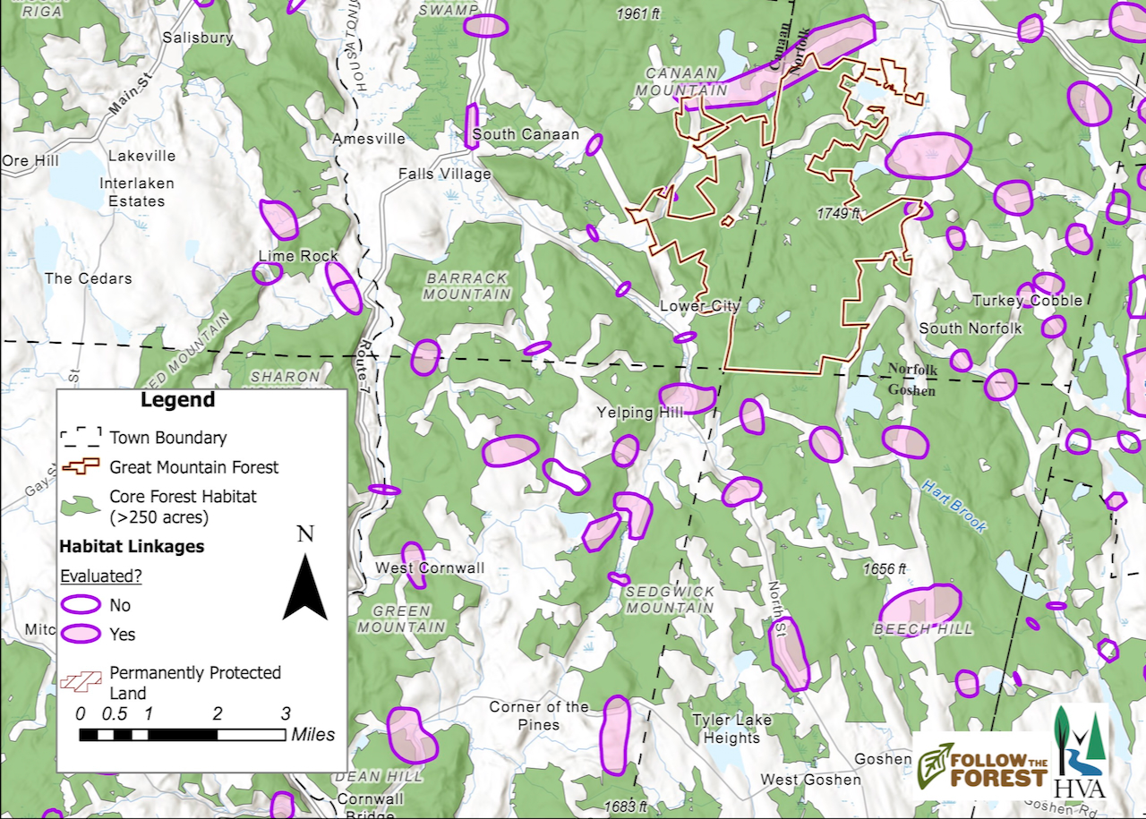
The property lines of GMF, outlined in red, with the surrounding wildlife linkages to other core forest habitat demarcated by purple ovals. Shaded ovals indicate sites that have been assessed in person by a community scientist. Map courtesy of Stacy Deming/Housatonic Valley Association.
Not just a stronghold, GMF is also surrounded by linkages to other protected habitats. These sites, identified by purple ovals on the Follow the Forest map, were initially identified by computer modeling, but many have been visited by volunteer citizen scientists who contributed their own observations to the data pool.
Stacy Deming, HVA’s GIS manager who is behind Follow the Forest’s intricate and user-friendly story map, also joined the interview. She spoke with pride about the collaboration with locals. “I’d say we’ve really done a lot of work with community scientists to come up with these,” she said of the map tags detailing each linkage. “I feel like they’re a better display of what the linkages really are.”
Rogers echoed Deming’s sentiment: “What’s really cool about getting community scientists out there is that they have information that we can’t gather from a computer.” Plus, involvement begets interest, she said, noting that the project promotes engagement with the idea of wildlife connectivity as volunteers inspect these linkage sites firsthand.
Both Rogers and Deming agree that a communal approach to preserving connected wildlife corridors is essential in southern New England, a region abounding with roads, property lines, and town borders.
“None of us can do it alone,” said Rogers. “We need each other. And what’s fun about Follow the Forest is that it unites all of us under something that’s exciting, right?”

GMF’s Resident Moose are the Subject of Scientific and Photographic Study
Great Mountain Forest is home to 20 of Connecticut’s 100 or so moose. Yet most people who visit the forest will never spot one. That’s because despite their significant stature and status as New England’s largest land mammal, these ungainly ungulates—members of the order of hoofed mammals— move through the forest with remarkable stealth and agility.
Wildlife photographer Stephen Schumacher, however, who has been documenting GMF’s diverse fauna for eight years, has captured GMF’s resident moose on multiple occasions. And Ed Faison, senior ecologist at the Highstead Foundation, a regional conservation organization based in Redding, CT, has studied GMF moose to better understand how they impact temperate forests.
Under the Microscope
Faison, the lead author of a recent paper on the effect of moose and white-tailed deer in New England on forest regeneration, explains “Moose have been studied for decades in the boreal forest, in Canada and Scandinavia and Alaska. So a lot is known about what they do to forests up there, but very little is known about what’s going on down here [in the temperate forest].”
Moose are relative newcomers to Connecticut. In fact, there is no hard evidence to suggest that the species had a stable breeding population in the state until the 20th century.“GMF is a great study site because it’s one of the few spots in Connecticut with moose, it supports long-term research and is actively managed” explains Faison.
Faison along with Steve DeStefano from the United States Geological Survey Collaborative Wildlife Research Unit at the University of Massachusetts spent 15 years monitoring the browsing (foraging) habits of moose and deer to determine their impacts on the abundance and composition of a re-growing forest in a disturbed woodland site, such as an area that had been cleared for timber harvesting. GMF proved an ideal study site.
A moose that eats up to forty or fifty pounds of food per day can certainly produce notable effects on the reemergent trees. Faison and DeStafano found that rather than restrict the forest’s ability to regrow, as prior scholarship had suggested, browsing’s primary impact was to direct different plant species to succeed in the disturbed environment, without substantial sacrifices to overall biomass or biodiversity.
The study, Resilience and Alternative Successional Trajectories in Temperate Forests Exposed to Two Large Herbivores published in the journal Forest Ecology and Management in June, concluded that the moose and deer did not significantly impact forest resiliency, or its ability to regrow after disturbance.
However, the scientists also concluded that the moose and deer’s feeding habits did affect the forest’s composition. The browsed sites showed markedly reduced deciduous tree growth. That’s because the animals favored deciduous species, allowing white pine (Pinus strobus) to grow more abundantly in the browsed stands.
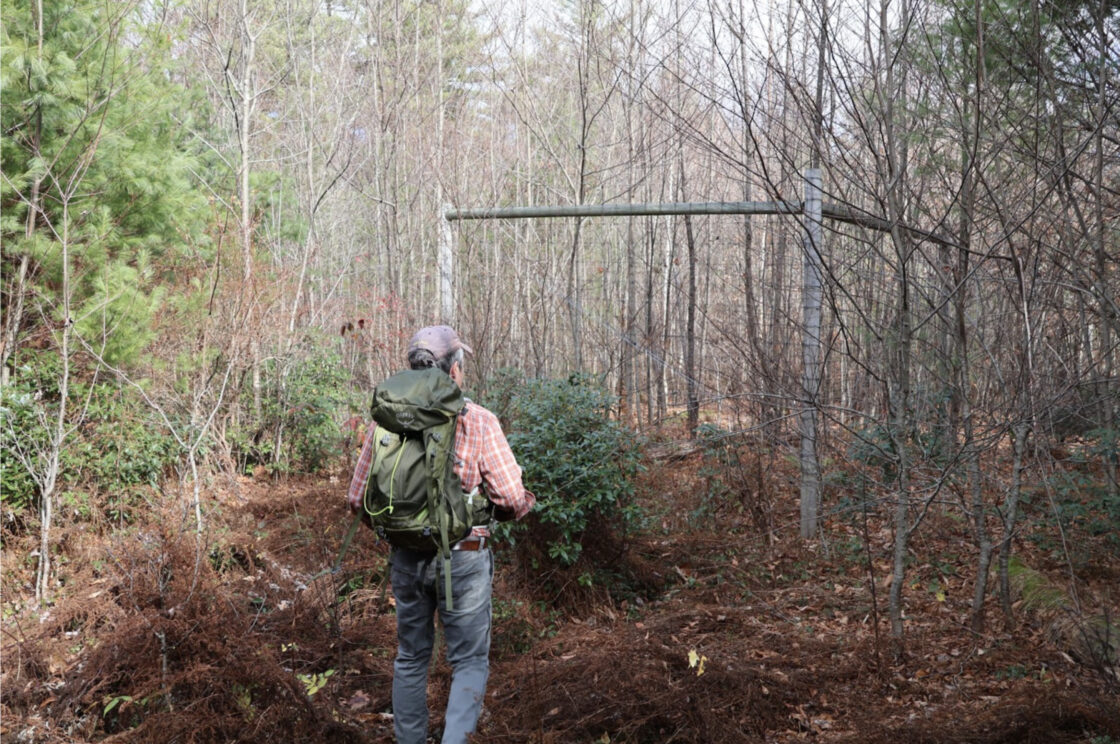
Faison inspects a partially enclosed plot that excludes moose but permits deer. Photo provided.
Through the Camera’s Lens
Rather than their impacts on the forest, wildlife photographer Stephen Schumacher is interested in documenting the animals themselves, which is no easy feat.
Despite being New England’s largest land mammal, moose are seldom seen. And even though their antlers can span up to five feet across, these ungainly looking, yet agile animals manage to negotiate the dense understory with remarkable ease.
“I’ve seen moose going through mountain laurel that is thicker than thick,” remarked Schumacher during a recent conversation. “It’s hard enough for me to get through there.”
Yet Schumacher persists. “This is a lifelong project,” he says. “I still want to get my quintessential moose in early morning or late afternoon sun getting lit up like a Christmas tree.”
Not only does their reticent nature make moose encounters a challenge. But a moose that feels threatened can kick, charge or stomp, particularly a cow protecting her calf.
Schumacher’s dogged pursuit of moose has meant he’s had his share of run-ins with the woodlands giants, and the pictures to prove it. On August 27 this year, while riding his bike, Schumacher spotted a looming shape emerging from the edge of the woods. Jumping off his bike, and struggling to keep his hands steady as he prepped his camera for the shot, Schumacher uttered a low guttural sound to draw the huge bull’s gaze.
Normally, the photographer wouldn’t vocalize to the animals, but since this was before rutting season, he said the bull was calm. “His ears were up… he wasn’t posturing with his antlers. He was relaxed.”
To Schumacher’s amazement, the bull offered a reply. “He turned his head broadside, and he looked back at me, and he answered me back.”
“It sent chills up my spine,” he continued, after a pause.
“Seeing that bull, that’s probably the coolest thing I’ll ever encounter. And I’ve been able to photograph wolves out in Yellowstone,” he said.
Schumacher has been tromping around GMF’s hinterlands for eight years, and he also monitors a number of trail cameras he set up around the forest, which gives him rare access to documenting moose as well as other mammals in the wild. Once, five years ago, two deer walked by one of his cameras and for a split second, the outline of their antlers matched perfectly. “Those guys were actually twins,” Schumacher said with a grin. Schumacher’s cameras have also captured fishers, martins, coyotes, foxes, bobcats, and “lots of bears—some giant bears.”
“I don’t take any of that for granted,” he said, emphasizing his gratitude to GMF staff for allowing him the access to do what he does. “It’s like getting a golden ticket in Willy Wonka.”
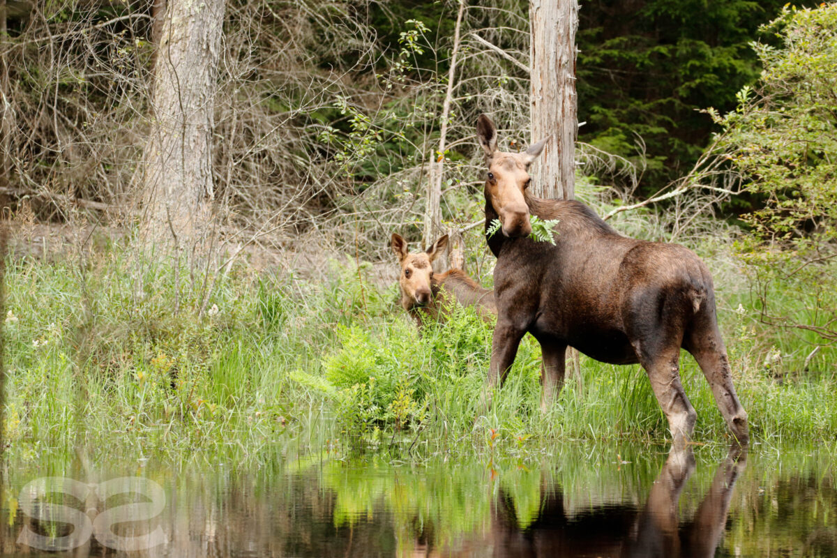
Despite his hands quaking with trepidation, Schumacher managed to capture a few images of a moose cow and her calf. Photo: Stephen Schumacher
Schumacher’s photographs and trail camera footage can be found on instagram @sds.wildlifeimages.
Misunderstood Asters: A conversation with Horticulturist Deb Munson
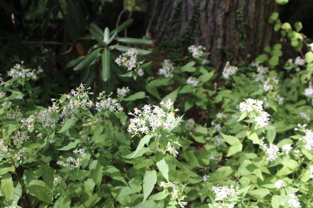
August has come and gone at last, the kids are back at school, and the forest floor is blanketed in white. While recent weather patterns have made anything seem possible, this is not the result of a historic Labor Day blizzard, but rather the on-schedule flowering of Eurybia divaricata, or, as it is commonly known, the white wood aster.
Expert horticulturalist, native plants advocate, and close GMF neighbor Deborah (Deb) Munson advises homeowners who see that snowy carpet abutting their yards at the forest’s edge to welcome the asters. They bring a host of late-season benefits to the garden and broader ecosystem alike.
“I think asters are very misunderstood,” said Deb in a recent interview, “which is unfortunate because they’re one of the greatest plants for pollinators and caterpillars,” second only in caterpillar hosting to fellow autumn-flowering goldenrod. The white wood aster is among the first of the New World asters to bloom in late August, and it has already brightened the dry and shady corners of Northwest Connecticut’s yards and woodlands.
If you’ve glanced out from your kitchen window in the past week, taken a recent stroll on one of GMF’s trails, or paid a long-weekend visit to your garden, chances are you’ve seen these late bloomers thriving under dappled sunlight, their individual stems mingling with their neighbors to create a veritable stronghold of delicate white blossoms.
The white wood aster’s ability to cover ground so extensively can alarm home gardeners and yard keepers who may find them to be “messy and weedy,” Deb said, but she assured that they provide a wealth of services.
That ability to provide a herbaceous groundcover is actually one of the aster’s greatest assets, she explained. “I believe in plants sort of being their own mulch,” Deb said, and the white wood aster can provide a perfect “carpet” in shadier portions of one’s garden or at the fringe where the yard meets the forest. She explained they flourish in the “ecotone” area at the woodland edge, or under a canopy that provides dappled shade.
Letting the garden, yard, or woodland mulch itself with understory plants and autumn leaf fall keeps the ecosystem contained, protecting against diseases or invasive species that could be brought in by an external material. Plus, it’s cost effective: “you pay people to take your debris away, and then you pay them to bring in mulch.” Deb suggested it’s cheaper, simpler, and safer to let the plants do the heavy lifting for you.
Plus, they’re self-sufficient. As they self-sow and are generally hardy, they require little maintenance. In Deb’s words: “They’re pretty carefree.”
Deb pointed out that like many other native fall-blooming wildflowers, they are drought-tolerant, unlike lots of non-native species that are sold at garden centers: “Native plants are adapted to our region, and they have more resiliency… I feel like it’s pretty dry right now, but it doesn’t seem like the asters are skipping a beat.” As erratic weather patterns, including droughts, persist, species that are able to withstand dry weather will continue to provide vital ecosystem functions and also, in the case of garden and yard populations, save water for homeowners.
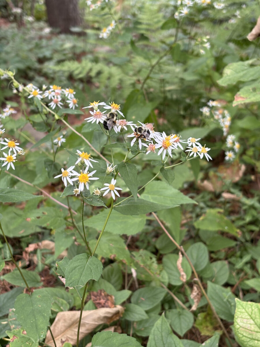
Photo by Alec Linden
And finally, aesthetics matter – as Deb put it, “they’re beautiful.” Since they are plants that flower in autumn, their comparatively humble springtime appearance of green, serrated foliage may entice many gardeners to pull them prematurely, unaware of the decorative potential in just a few months when the most glamorous spring ephemerals have long since shed their petals. Their good looks serve an ecological purpose too, bringing in bees, butterflies, and other late-season pollinators whose options for a meal are dwindling.
“If you’re not too tidy and antiseptic about your woodland edges, you could have an amazing display of asters and goldenrod,” Deb said, among other misunderstood yard-dwellers such as white snakeroot (Ageratina altissima). “I look out on my woodland edge, right off my porch, and I’m looking at goldenrod and aster divaricata (Eurybia divaricata), the white wood aster, and there’s Symphyotrichum cordifolium there.”
Deb advised the curious to keep their eyes peeled for a number of other fall flowering perennials just starting to show their colors: the deep purple New England Aster (Symphyotrichum novae-angliae), the flat-topped aster (Doellingeria umbellata), and the smooth aster (Symphyotrichum laeve), in addition to many others.
Deb said that she feels American landscaping aesthetics have erred too far in the direction of the sterile, and that she encourages homeowners and land managers in the Northwest Corner to embrace a “wilder” sensibility in their gardens and properties. Not only does welcoming fall wildflowers bring a jolt of color to one’s yard as the days ruthlessly shorten, but it establishes a communion between the home and the broader ecosystem that has largely eroded in much of modern Western life.
“I think learning your land is an important thing to do,” Deb said, and she has the resources for those looking to get started. For field guides, she recommends Lawrence Newcomb’s Wildflower Guide and Ted Elliman & New England Wild Flower Society’s Wildflowers of new England. She also suggests two introductory guides on local native plants: Native Plants for New England Gardens by Mark Richardson and Dan Jaffe and The Northeast Native Plant Primer by Uli Lorimer.
For those looking to chat directly to expert gardeners or start preparing for their own native plant garden, Deb has a list of local nurseries specializing in wild plants to check out: Lindera in Falls Village, the Native Plant Trust’s nursery Nasami Farm in Whately, Massachusetts, Earth Tones Native Plants Nursery in Southbury, Connecticut, and Helia Native Nursery in West Stockbridge, Massachusetts.
Reflections from Meekertown – 24 hours alone in the forest
In late May, in my role as GMF Newsletter Editor, I had the opportunity to spend the night at the Meekertown Cabin, a rustic but cozy outpost on the site of a onetime homestead at the southwestern extremity of this 6,300 acre forest. The objective was to produce the article you now read; whatever happened between embarking and inscribing was up to me.
In Connecticut, our forests are many, but they are crosshatched by private property, highways, and development. For all its rural charm, the fourth most densely populated state in the country offers little in the way of true wilderness. For those of us in the Northwest Corner, though, Great Mountain Forest (GMF) gives us something pretty close.
The following report is an account of a night spent alone in some of Connecticut’s deepest woodlands, with the only goal being that I allowed myself to be led by the experience instead of following a pre-planned agenda. When we’re alone in the woods, who leads us? And where do we go?
Setting out
GMF Property Manager Russell Russ picked me up on a sunny afternoon and ferried me from the East Gate entrance along the well-maintained Camp Road, onto Chattleton Road, and to the West Gate on Canaan Mountain Road.
Along the way, Russell identified the complex human interventions on the landscape that make it what it is today. Russell essentially grew up in these woods, his father Darrell being a longtime forester manager at GMF who, throughout the 20th century, essentially shaped the forest we see today alongside forester and owner Ted Childs. He pointed out a stone dam below Old Man McMullen Pond with an ancient outlet pipe, below which sits the subtle remnants of an old saw mill, once one of the major vocations of this now uninhabited stretch of highland forest. Further along, Russell explained that the stands of non-native conifers that hemmed the road had been planted as an arboretum for exotic evergreens.
As much time as Russel has spent in the forest, he was quite visibly surprised by the sight of a cow moose, grazing languidly on the Big Island of Old Man McMullen Pond, which we spotted from the window of his truck. With wide eyes, Russell said that in two and a half decades working full-time in the forest, it was the first time he’d seen a moose at this pond. While we watched, a beaver cut a clean V in the still black water just in front of the moose enjoying a leisurely lunch.
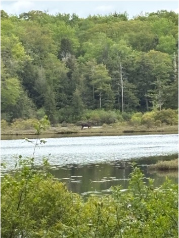
The best photo of the moose we managed, just barely within zoom range.
After exiting the forest, 15 more minutes brought us down the slopes of Canaan Mountain, out onto Route 63, and eventually onto North Goshen Road, where the chauffeured portion of my journey abruptly ended. Russell handed me a stack of paper maps, some parting bits of advice, and peeled off back to civilization.
My guides:
The ferryman
Buzzing with the anticipation of 24 hours of solitude in an unfamiliar place, I felt like Odysseus, ferried by Charon across the River Styx, even though the TV-sized display screen of his new Toyota Tacoma blared in front of my face. Russell was conveying me to an unknown frontier, depositing me at the forest’s wild southern boundary. He imparted the knowledge that would enable me to find my way through the tangle and keep me on the known path without getting lost.
But getting a little lost, of course, was part of the plan. Searching for Russell’s landmarks – the Collier’s Cliffs overlook, Pothole Falls, and several other remote curiosities of the wild Meekertown area – brought me on bushwhacking missions. I etched through thick undergrowth and scrambled up the slick bedrock exposed by the rush of Brown Brook’s cascades in a gambit to rediscover Meekertown Road, which I’d left behind some time before. Halfway up, I paused for a dip into a rust-colored pool as the light faded from the understory, and felt wonderfully a part of the darkening forest around me.
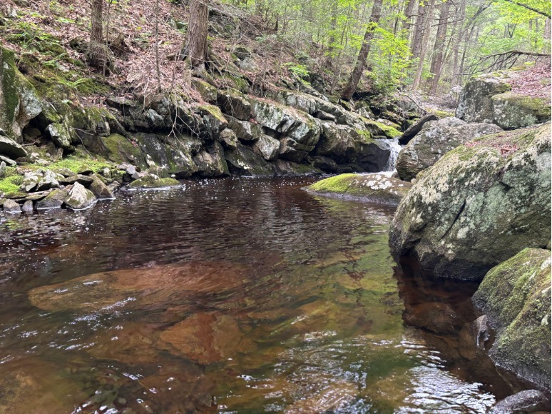
The grotto-like, rust-colored pool somewhere on Brown Brook
The bears, beavers, and beyond
I followed Russell’s directions up the verdant road until I crossed a bridge that brought me back into GMF territory and up a trail that would eventually intersect with the historic Meekertown Road near Wampee Pond. I began to spot mounds of bear droppings, a day or two old – a signpost of another type of guide in the forest.
These roads, though grown over and seldom used today, were once the conduits for thriving industry in these hills. Their legacy as thoroughfares is carried on today by the animals who have returned to habitats once wrested from them by the enterprises that built the roads.
As I arrived at Wampee Pond, taking in its boreal affect, a northern water snake cut s-shapes across the still, ink-black surface while two beavers busily reinforced a dam at an outflow of the aptly-named Brown Brook, which runs dark with the tannins of organic detritus steeping in its cold waters.
I tried to channel the animals’ movements across the landscape as guidance for my own. When multi-stemmed, heavily branched fallen trees blocked the overgrown corridor of the lower Meekertown Road, I followed the dim impression of deer tracks, to navigate the blockages obstructing my path.
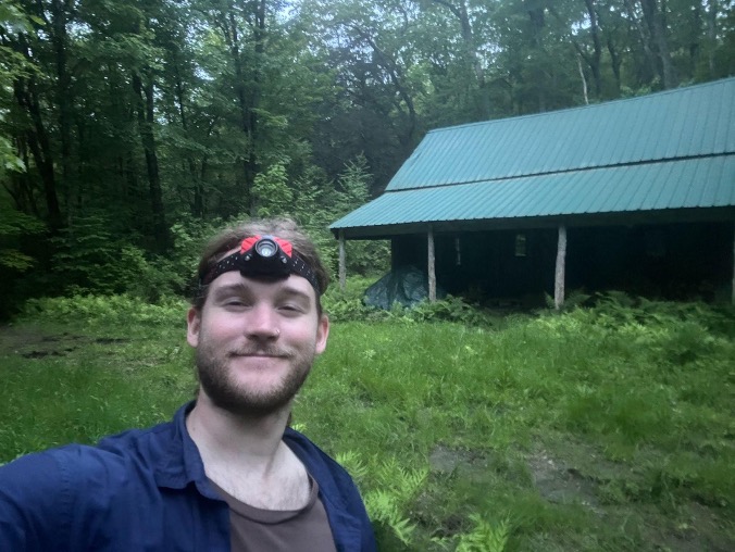
The author settling in for the evening at Meekertown Cabin
The colliers
That these animals are able to flourish – even impose their own will – upon a landscape once denuded by 19th century industrialism is remarkable. “It was a wasteland,” said former GMF director Hans Carlson on a recent phone call, emphasizing that resilience and resurgence are core aspects of GMF’s forest history. The now-verdant hills were stripped of vegetation to fuel the colliers’ fires, and the hollows subsumed by miasmas churning from charcoal hearths and pig iron blast furnaces.
When the colliers tended their fires here, there would have been no bears sharing the roads, no beavers laboring in Wampee Pond (which didn’t exist – it was dammed in the early 20th century as waterfowl habitat and forest fire protection). Traces of their hearths are found throughout the forest, and the Meekertown area would have been sporadically populated by these solitary, hardened men who were likely haunted by their desolated landscape.
There are lurid stories of murder and mischief whispered about the past inhabitants of Meekertown. In 1820, a clergyman described the settlement as a “hamlet of heathens, living in intellectual, moral, and spiritual darkness,” which GMF recently immortalized in a series of t-shirts and is also referenced in the name of a beer brewed by nearby Norbrook Brewery called “Hamlet of Heathens,” brewed with wild Meekertown-foraged hops.
While this reputation may have had some credence, the truth is that they were opportunistic, and maybe a little introverted, individuals who made their way in a difficult world. In any case, their stories, and the remnants of their hearths and shanties left behind, animate the landscape with a colder, more imperfectly human history entangled with the vibrancy of the forest that flourishes today.
Meekertown Road is split in two, where Brown Brook burbles over the long-collapsed remnants of a bridge before it cascades to the valley floor below. While I sat in that spot, listening to the tea-stained water rush over the rocks, the occasional roar of a semitruck from Route 63 broke through my reverie. GMF, as wild as it feels today, is still susceptible to industrial intrusions from time to time.
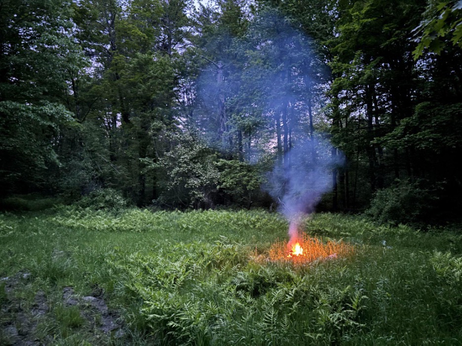
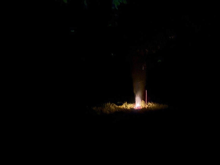
While the colliers may have not been focused on the trees and birds like many of our modern forest goers, they were certainly attuned to their fires. I meant to avoid cosplaying collier during my overnight stay at the cabin, but as evening fell I found myself tending to a smoldering blaze in the clearing just outside the building.
It’s difficult to imagine the life of a collier, staring intently at a pile of timber and earth for weeks on end, measuring its interior heat by the color of the smoke that rose from the mound. There would have been none of the hooting barred owls or rustle of the breeze in the treetops then. I have a note in my journal that I must have scribbled out there: “It’s amazing how long you can watch fire. It’s almost difficult to do anything else.”
The storyteller
I woke the next morning on the wooden floor of the cabin, the beaming sunshine illuminating the many inscriptions etched into the walls from the scout troops, artists, and hunters who had previously taken refuge within its walls. The two rocking chairs which face the formidable hearth at the front of the room sat eerily still as dust motes fluttered in the sunbeams.
“Don’t sit in Mrs. Dean’s rocking chair!” GMF trustee and forester Star Childs had told me the day before with a mischievous grin. “If it starts rocking, get outta there.” Luckily, nothing moved during my short stay – that I saw, at least.
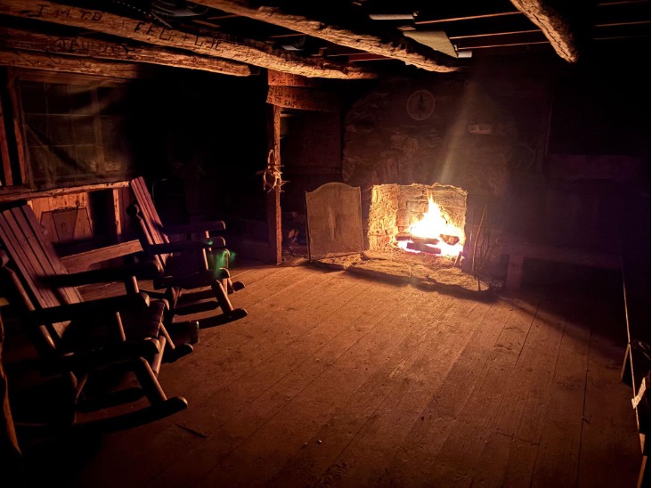
Which one is Mrs. Dean’s?
Having my route back to the East Gate more or less mapped out, I contemplated backtracking east on Meekertown Road a little bit to search for the gravesite of several onetime residents. The late environmentalist and poet David Leff wrote rhapsodically about GMF’s landscape, its tenacity and will to survive, and he described its former inhabitants with the same reverence.
“Meekertown’s ghosts are never frightened,” he wrote in a yet-unpublished paean to the forest. “Their tales linger.” On his own visit to the graves, Leff reflected somberly on their memory: “We show our respect by quietly keeping the stories alive, as best we can.”
Leff’s writing guided me to try and see the forest as he did – as a patchwork of animations and presences, each contingent upon the other. Leff showed that GMF is constituted by the stories that dwell in the minds of the foresters who have spent their lives within it, and the memory of those who made homes and lost them here, just as much as it is by its trees, hills, and hollows.
Having fulfilled my bushwhacking quota the previous evening tromping around Meekertown, I decided to let the graves lie. And anyways, as presumably solitary individuals in life, maybe they appreciate their alone time in death too.
A guide for the reader
With that decision made, I turned left onto GMF’s north-south arterial, the refreshingly obvious and debris-free Number 4 Trail, and began my journey home. What follows here is my attempt to pay it forward: as I was guided through my time in the forest, perhaps this suggested route – which I can confirm is well worth it – will inspire the intrepid rambler to undertake their own journey from GMF’s wild southern reaches to the East Gate Campus..
As a disclaimer, any distances given are estimations, and anyone wishing to walk these trails should consult a map, available on the GMF website.
Find your way to the intersection of Meekertown Road with the Number 4 Trail. Getting to this point means either hiking in on route of your choosing, or devising another creative access plan. For a detour to the Meekertown Cabin, follow Meekertown Road west about a half mile to a clearing where the cabin is easily seen, then turn around and head back to the junction. For those who want to skip the cabin, start heading north on the Number 4 Trail with Wampee Pond to the right. Make sure to spend a minute searching the surface for disturbances from snakes or busy beavers.
Continue up the Number 4 Trail for another 2/3 of a mile or so before coming to a small clearing on the left after a bit of an incline. At the back of this clearing, an obvious but small trail leads to the best view I’ve seen so far in the forest: Wapato Lookout.
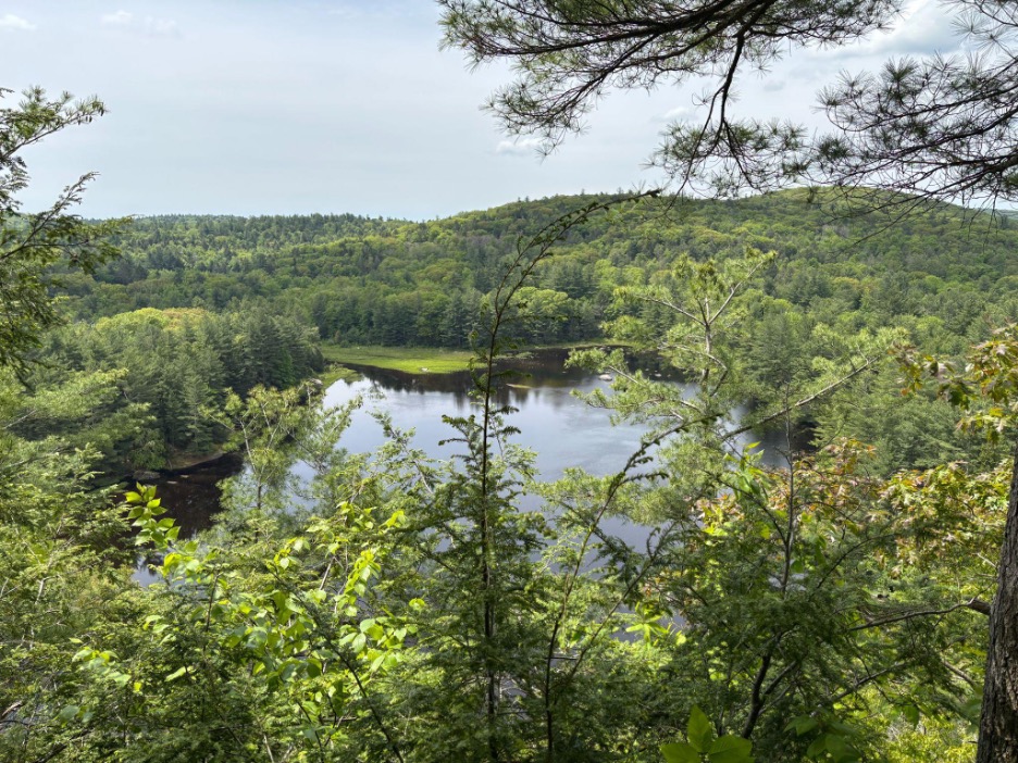
The view. It’s even better in person.
From a dramatic precipice, the view extends through a white pine-framed window over the black waters of Wapato Pond and rolling peaks beyond, exemplary of the adage that GMF often feels more like New Hampshire’s deep woods than southern New England. I spent a good 45 minutes here, swatting mosquitos and enjoying a respite on the bouncy, needle-strewn soil. It’s the type of spot one could spend quite a bit more time at with the right schedule.
Heading back to the Number 4 Trail, continue north for a little over a mile through varied woodlands until the Sam Yankee Trail peels off to the left. Follow it for a few hundred yards, until a well-marked sign points left to the Matterhorn. Enjoy the short but stimulating climb to the rocky precipice in the heart of GMF, with nothing but rolling woodlands around you. Enjoy your lunch here, and be careful with the lichens.

The author, post-lunch and perched on the Matterhorn
Backtrack to the trusty Number 4 Trail, and continue heading north. After another mile or so, turn right, rounding a gate onto the Crissey Trail, where a mystical forest of hemlock and slim maples towers above a formidable network of low stone walls.
After a while, turn left onto the shady and boulder-strewn Crossover Trail. If inclined, take a detour to the Crissey Pond overlook for another fabulous view. Head back to the Crissey Trail and continue on to GMF’s famed glacial erratics, large boulders dropped during the retreat of the Laurentide Ice Sheet. As a rock climber, I found myself atop one of them, hanging out with a ruby-throated hummingbird on a bed of ferns and moss.
The Crossover Trail spills out to the Camp Road, where one can head back to the East Gate through a corridor of hemlocks and yellow birches for another taste of the north country, making sure to stop at the model charcoal pile exhibit demonstrates the complexity of charcoal fires.
My iPhone clocked the total mileage, with all the detours, to be between seven and eight miles. For those who want more, a spur loop to visit the prehistoric Tobey Bog can be achieved via the Overlook Trail, Charcoal Pit Trail, and Tobey Bog Trail.
Happy hiking!

An afternoon in the Pleistocene

Peeking around the berry bushes into the Tobey Bog’s central clearing
The oft-maligned swamp, despite holding a persistent legacy in the cultural imagination as a place of decay with little utility or aesthetic appeal to humans, has garnered several famous fans over the years. The animated ogre Shrek, famed for his protectiveness over his marshy homeland, comes to mind as a recent example, though bogs have another, arguably more eloquent devotee: Henry David Thoreau.
“Yes, though you may think me perverse, if it were proposed to me to dwell in the neighborhood of the most beautiful garden that ever human art contrived, or else of a Dismal Swamp, I should certainly decide for the swamp,” the Transcendentalist thinker wrote in his 1851 treatise to wildness, “Walking.” In that lecture, Thoreau waxed poetic about replacing his cultivated front yard with “a few square rods of impermeable and unfathomable bog,” romanticizing the rawness of the bog in comparison to the orderliness of human landscaping.
Before I embarked on an afternoon visit to the bog on a gorgeous day in early June, GMF trustee, forester, and founding member Star Childs told me that he’s always identified with that particular fantasy of Thoreau’s. In fact, he’s been lucky enough to have lived much of his life with a swamp in his figurative front yard – namely, Tobey Bog in the “North Forty” region of GMF.
Tobey Bog is no ordinary wetland, at least not in Connecticut. In his as-yet unpublished paean to the forest, the late naturalist-poet David Leff, whose lifelong love affair with the GMF landscape began with an encounter with the bog, described it as “a subarctic fragment stranded about as far south as possible,” and, “a world unto itself where the usual ecological rules did not apply.”

A glimpse of Tobey Pond from beneath the hemlocks
Paddling out
Aided by the convenience of a canoe (courtesy of the Childs family), I took advantage of some rare good weather to ferry myself across Tobey Pond for my first visit to the bog. Paddling across the pond’s dark, serene waters, fringed by drooping hemlock boughs and tall stands of white pine, the experience felt more North Country than southern New England.
Tobey Pond, like the bog with which it shares a namesake, is a specter of the ice which once weighed heavily upon these hills. When the glaciers retreated at the end of the ice age, they left behind chunks of ice lodged in the ground, which created holes known as kettles that filled with meltwater. While Tobey Pond became a lake, suitable for things like canoeing and town beaches, Tobey Bog was poorly drained and poorly fed by water sources, eventually filling with a thirty foot thick bed of sphagnum moss from which now sprouts a strange array of conifers, berry bushes, and carnivorous plants. As I would soon find out, it was, in Thoreau’s words, “the jewel which dazzled me.”
A pocket of the cold north
Parking my canoe in a shady cove of the pond, I ambled by Skinner cabin and down a gravel road to a thin boardwalk leading through a claustrophobic tunnel of highbush blueberry, huckleberry, and invasive buckthorn shrub. Eventually, the brush parted to reveal a panoramic view of the bog which Leff described as resembling “a shag carpet of the 1970s” due to the mosaic of “heathered green and reddish highlights.” I agreed with Leff that the amphitheater-like space conjures the feeling of being within a “huge oculus in a massive rotunda.”
Ecologically, it recalls imagery of the boreal peat bogs of high latitude North America and Europe. Scrubby conifers perch upon a squishy bed of sphagnum moss that compresses at depth to form peat, a thick mat of organic material that is used as a fuel source in many parts of the world, or as in Scotland, to flavor liquor. Trees like red maple, larch, and white pine dominate a patchy overstory, while scrubby black spruce mingle with the berry bushes in the shrub layer, reminiscent of the landscapes of northern Maine or Atlantic Canada.
“It’s a little mini-ecosystem all of its own that attracts these northern species,” Star said.

One of the only deciduous conifers native to the US, the eastern larch, also known as the tamarack, thrives in boggy soils
These trees and shrubs can survive in the nutrient-poor, acidic soils that the bog provides, as can a much stranger, smaller, and hungrier flora: carnivorous sundews and pitcher plants. While the tiny sundews eluded my layman’s eye, the purple pitcher plant – the only species of its kind that tolerates cold weather – was obvious, with deep green and magenta leaf furls curling into the eponymous pitchers that trap prey to provide the valuable nitrogen the bog itself cannot provide. In little hollows beneath the shrub branches, the fleshy, bulbous blossoms of the plant, just opening at the time of my visit, stood from the moss like troupes of elves in dappled, emerald sunlight.
While this bog took thousands of years to form, it feels like a vestige of the Pleistocene era, when the land had just shaken itself free of its icy burden. The effect is amplified by the drone of frogs echoing through the larches and the thrum of dragonfly wings beating past my ears. It’s easy to grow fanciful here. Michael Gaige and Yonatan Glogower’s 2016 field guide to the forest recommends that readers should “go [to the bog] when you need to find some peace in your life, albeit of the soggy, acidic variety.”

The bulbous blossoms of the purple pitcher plant looking very Dr. Seuss among the moss and sedge
Timeless – but vulnerable
Tobey is “a true quaking bog,” said Star before I embarked. And quake it does. While the two-plank boardwalk feels solid enough underfoot, a subtle bounce under each step suggests the true nature of the gelatinous substrate beneath.
This shake, just a hint of unsteadiness, reflects the fragility of the ecosystem itself, no matter how ancient and timeless it may feel to a human visitor in this strange blip in geologic time. The existence of a peat bog is defined by the input of water outpacing its loss through evaporation and plant respiration, which makes them particularly susceptible to changes in temperature and precipitation.
Bogs further north, known as ombrotrophic bogs, receive the entirety of their water from precipitation, and are reliant on cool temperatures to keep from drying up, which is why they don’t occur as far south as Connecticut. As abnormally warm summers increase in frequency, disproportionately impacting arctic and boreal regions, these bogs are at risk. A 2020 study conducted in the Black Forest region of Germany (which somewhat resembles the rugged but low hills of Northwest Connecticut) found that biodiversity in temperate bogs has already been impacted by climate change, and remains threatened due to rising temperatures and decreased precipitation. The study maintains that there are few management options available to combat these trends.
When these bogs dry up, they can also burn. There has been ample research conducted in recent years on the environmental impacts of smoldering wildfires on peatlands, which can quietly burn in the soil for years, overwintering deep in the peat layer. Peat bogs contain a large percentage of the world’s terrestrial carbon stores, similar to the amount held in the atmosphere, and fires can release massive amounts of the gas. A 2021 study on northern peat fires reported that arctic wildfires are on the rise, and have been contributing significantly to greenhouse gas emissions. If warming temperatures continue unmitigated, the study predicts that annual carbon loss from peat souls could total almost 550 megatons per year.
As this carbon is released, it contributes to global warming which is already disproportionately affecting northerly regions. This warming in turn melts more permafrost and dries out the soil, thus allowing more fires to ignite, which as a result puts even more carbon into the atmosphere. It’s what climatologists call a positive feedback loop.
Tobey Bog is minerotrophic, meaning it receives supplemental water through ground seepage. Due to its limited size it is not a great carbon store itself, and its moisture content is supported by the additional groundwater it receives. It too, however, is at risk from rising temperatures and changes in precipitation patterns, as decomposition rates can increase “dramatically” with warmer weather, penetrating the deep peat layers of preserved organic material, according to Gaige and Glogower. Its reliance on peripheral water sources also puts it downstream of any impacts to those resources.

A window to the north
Connected futures
Former GMF director Hans Carlson ran a column in the “Norfolk Now” contemplating the natural and cultural history of the region’s landscape in the late 2010s, including an article on Tobey Bog, a place which he said has largely remained on the outskirts of Western interest. Now, though, the bog is no longer able to sustain an existence separate from the human behavior, even as it gains value in the eyes of conservationists and nature-lovers. Carlson’s words on the subject, written nine years ago, are more potent now than ever: “We will continue to leave Tobey Bog to its own processes and life cycles, preserving it as a rarity in Southern New England, but it is no longer a place on the margins of our choices.”
Many of our leaders and decision-makers could benefit from a trip to the bog. It captivates and enchants, and thus, perhaps may encourage the right choices. Gaige and Glogower reference a 1991 master’s thesis by Erica Hamlin in which she told the story of Tobey Bog’s ecology through creative scientific prose and charcoal drawings. “It is a good reminder that strange ecosystems like bogs have the power to inspire people across disciplines and cognitive frames,” they write.
Or, as Thoreau said: “Hope and the future for me are not in the lawns and cultivated fields, not in towns and cities, but in the impervious and quaking swamps.”

Healthy forests, healthy people – and healthy ticks?
The hills are alive in Northwest Connecticut, but it’s not all birdsong and snowdrops: the blacklegged tick has shaken off its winter torpor, and now crawls in droves through the understory, spreading disease and myths in equal measure.
Dr. Scott Williams, Chief Scientist and Head of the Department of Environmental Science and Forestry at the Connecticut Agricultural Experiment Station (CAES), a state organization spearheading research on tick-borne diseases, dismissed two commonly held misconceptions about the tiny, dangerous insect: “They don’t fly. They don’t drop out of trees.” Williams advised that rather than worry about the branches overhead, think low and keep your ankles covered. “They crawl up from the ground for the most part, or [from] a few inches off the ground.”
Demystifying tick behavior and pathogen transmission yields surprising insights into how to manage disease levels in our region: in a healthy forest, more ticks might actually equal less disease, Williams explained.
Debunking Myths
Blacklegged ticks (also widely known as deer ticks) and Lyme disease are commonly misunderstood components of the New England forest, starting with the illness’ origin story. Conspiracy theories abound speculating where it began, with an especially persistent and oft-debunked claim that it leaked from a government research facility on Plumb Island.
But reputable research has shown that the disease has been circulating in the northern hemisphere for millennia. One of the bacterium responsible for causing Lyme disease, Borrelia burgdorferi, was detected in Ötzi the Iceman, a 5,000 year-old mummy found in the Eastern Alps in the 1990s. A study conducted by the Yale School of Public Health in 2017 traced B. burgdorferi back to North American forests of 60,000 years ago, meaning the bacterium was resident in our woods long before the earliest human inhabitants arrived.
Closer to home
Deer ticks and Lyme disease are as Connecticut as New Haven pizza, with one of our picturesque coastal towns lending its name to the ailment after a cluster of cases there in the 1970s lead to its identification as a unique condition. The state remains positioned in the very heart of tick country, and the Icebox of Connecticut, which previously benefitted from the protection of its harsh winters, is losing its defenses as the cold season continues to warm up.
“We’re not trying to scare people from being outside, we’re trying to educate people on when the various stages [of ticks] are active – what’s tick habitat and what’s not,” Williams said. For instance, a field of high grass, commonly regarded as a tick haven, is actually largely inhospitable to the bugs, as they desiccate quickly in a dry environment. “That’s kind of a desert for ticks,” Williams explained.
The most “ticky” habitat “is really that edge where your lawn meets the forest,” he said, and when it comes to getting bitten, it’s often a matter of timing.
When to watch out
While adult deer ticks are active now, Williams explained that May, June, and early July are the months when most infections occur since that’s when both humans and the nymphal stage of deer ticks are likely to be active outdoors. Although the adult ticks wandering the undergrowth and brush now can certainly transmit the pathogen, it’s the nymphs that are “the really problematic guys,” Williams said, in part because they are small and hard to detect, and also because in spring, “human activity and tick activity in the nymphal stages coincide.”

A white-tailed deer in the forest. Photo: Mike Zarfos
Host competency and the dilution hypothesis
Active ticks, active humans, and an abundance of both yield higher bite rates, thus contributing to more infections. However, Williams explained that the species present in an ecosystem can have significant impacts on the spread of tick-borne pathogens to humans.
A surplus of white-tailed deer upon the landscape, for example, is often thought to correlate to more tick-borne illness. While a large deer population will often support a high concentration of ticks, deer are a “dead-end host” for the bacterium, meaning they don’t transfer the pathogen back into the ticks.
Mice, however, are “competent hosts.” The concept of host competency is the ability of a reservoir host species (animals that carry and spread disease-causing pathogens) to infect the ticks with pathogens, which small rodents are highly adept at whereas larger animals are less so. When deer are plentiful on a landscape, “you typically have high tick abundances with lower infections with the various pathogens,” Williams said.
The reservoir host species of B. burgdorferi that actually infects the ticks with the pathogen are small rodents, especially the white-footed mouse which is common to the Litchfield Hills. When fewer deer, and other medium sized mammals, are available, Williams explained that the ticks will then be forced to feed primarily on mice, which will support a smaller population of ticks within which the pathogen is much more concentrated.

CAES team conducts Lyme disease research with mice in Woodbury. Photo: Mike Zarfos
Healthy forests, healthy people
In a healthy ecosystem with a spectrum of animal species, ticks aren’t forced to rely on these highly competent hosts for a blood meal. Williams explained that this scenario, in a species-diverse forest, describes what disease ecologists call the dilution hypothesis: “with a diversity of animals, you’re going to see less infection in the ticks because they have so many options to feed.”
The loss of forest diversity can have the opposite effect, Williams said, which is happening across the Northeast due to development and the incursion of invasive species. Several years ago, Williams conducted research on the correlation of Japanese barberry, an invasive shrub, with tick populations; some of the work was done at Great Mountain Forest with the help of GMF forester Jody Bronson. The study found that the dense tangle of undergrowth created by the proliferation of the shrub caused a humid microclimate that not only provided great tick habitat, but enabled them to remain active throughout the day.
Normally, the moisture-dependent ticks might be inactive under a pile of leaves during the heat of the day, Williams said. But the microclimate created by the “monoculture” of invasive brush growth means ticks continue looking for a host “pretty much 24 hours a day.” He clarified that this was not specific to Japanese barberry, but any plant that grows in a monoculture tangle, “which is pretty much what invasives do in our neck of the woods.”
“What we’re trying to push is a healthy, diverse forest, and that’s very applicable to Great Mountain Forest,” Williams said. The goal, he continued, is responsible management: “If you have a healthy, diverse, well-managed forest, you’re going to have a diverse array of wildlife, and as a result you’re going to have a healthier tick population with lower pathogen infection. That’s kind of the bottom line.”
Where Are Our Winters
Winters in the Ice Box of Connecticut have been getting warmer, and this one is no exception. While the mercury did drop at times, data from the GMF weather station through February this year reveals a familiar trend: above-average temperatures and below-average snowfall.
GMF Property Manager and Head Weather Observer Russell Russ said that “the figures tell a pretty good story— or a bad story if you love snow.” Since 1998 annual (especially wintertime) temperatures have increased at the GMF weather station, while snowfall totals have decreased.
These trends have impacted long-cherished winter recreation opportunities in the Northwest Corner in tangible ways, shortening the Nordic and alpine ski season and eliminating ice fishing on certain lakes in especially warm years. Climatic changes have also had profound impacts on the ecology of forests—many of which researchers are just starting to understand.
The weather station and warming winters
The GMF weather station, known as Norfolk 2SW, is a National Weather Service (NWS) Cooperative Weather Observer Station. It is one of 165 stations in Connecticut which the NWS uses to catalog weather records, and has been used to record weather observations every day since January 1, 1932.
Russ is GMF’s lead weather observer, a position he took over from his father, Forest Manager Darrell Russ, in 2003. He has contributed an additional 22 years of weather data to GMF’s and the NWS’ records, building on the over five decades of readings provided by his father.

After Russ compiled data from the 93 complete annual records since 1932, he found that 10 of the 12 warmest winters on record at Norfolk 2SW were logged since the year 2000. 2024 holds the title as the warmest with an average annual temperature of 48.6ºF, 3.6ºF above the 89-year average of 45ºF from 1932-2020. 2023 and 1998 are tied in third place at 48.4F.
While this winter may have felt frigid at times compared to recent years, the data indicates that monthly averages have remained high, ranging from 5.3ºF warmer than normal in November to 0.2ºF above average in January.
No snow, no grow?
Temperatures this winter have at least stayed closer to normal than many recent years, however snowfall has lagged far behind. Only 38.4 inches have accumulated as of March 1, while the weather station normally averages 65.1 inches through February.

GMF weather observer Russell Russ poses after 24 inches of snow fell in October 2011.
Low snow years are becoming increasingly commonplace at GMF, which on average receives nearly 90 inches of snowfall. Last winter totaled only 45.5 inches of snow between October and May, making it the 6th least snowy winter in Norfolk 2SW’s records, while all similarly low-snow years have occurred in the past several decades. By contrast, only one of the top 15 snowiest years in Russ’ data archive came after the early 1980s – a particularly snowy 1995-1996 season.
Lower snow yields and warmer temperatures mean that a persistent winter snowpack blanketing the forest floor in Northwest Connecticut may be reduced or eliminated entirely, a scenario which could have negative impacts on forest ecosystems. Research within the past two decades has highlighted how the cold season is “functionally important” to the growing season, according to a 2012 study on snowpack decline and its repercussions in a New Hampshire Forest.
Long thought to be a “dormant season,” winter sees the active continuation of nutrient exchange between roots and soils, a process aided by the insulation of a robust snowpack. Kept at or above freezing, nutrients such as nitrate and phosphate circulate within root systems, keeping trees healthy. A thin or absent snowpack combined with cold temperatures, which has occurred extensively this winter, can freeze soils and interrupt this process. Key species of the New England forest, such as sugar maple and yellow birch, are particularly susceptible to deep freeze-thaw cycles like those of December and January this season. According to a more recent study on the impacts of climate change on winter-dependent biomes, a “deep and long-lasting snowpack drives water and nutrient availability at the start of the growing season.”
Another paper on increased winter runoff events emphasizes that “the synchrony of spring nutrient availability and nutrient uptake” – meaning when spring thaw and plant growth occur simultaneously – is important for natural ecosystems. The paper also finds that midwinter thaws “pose an ongoing and increasing risk to water quality in snow-covered regions,” but that further research is required to identify specific dangers.
Impacts from reduced snowpack and warmer temperatures extend beyond plants to which animal species may thrive in our woodlands. In several instances, white-tailed deer have been shown to succeed in landscapes with reduced snowpack, replacing moose as the dominant browsing species in winter. Different herbivores favor different tree species, so a shift in which herbivore is more common can lead to cascading impacts on forest plant communities, according to the 2024 paper.
Finally, the livelihood and function of a working forest may be altered by diminished snowfall. The 2012 study predicts the maple sap-harvesting season to be shortened by half and the sap yield reduced “by 20% or more” by the end of the century in New England. The paper also anticipates an earlier and prolonged mud season, potentially affecting winter timber harvests which benefit from frozen and snow-covered roads to protect soils from compaction and erosion.
Ice out
Reduced ice cover on lakes and ponds is “a key indicator of changing winter climate globally,” states the 2024 study, and this is consistent with GMF’s water bodies. Russell Russ has tracked ice-in and ice-out dates since 2000, and maintains that lakes and ponds are freezing over about two weeks later than in “the old days,” and melting about two weeks earlier.

Tobey Pond with open water in January, 2025. Photo: Alec Linden.
Northern lakes normally experience “inverse stratification” during normal ice cover, when colder water rises to near the surface ice and warmer water sinks beneath. Alternatively, when ice is absent from the surface, these lakes often stratify with warmer water layering above cooler water. Reduced ice cover disrupts the normal circulation of nutrients throughout the lake as the seasons change.
The 2024 study notes that these changes may affect phytoplankton, which serve as the base of the aquatic food webs. One report shows that a specific species of phytoplankton, the diatom Discostella stelligera, has become increasingly abundant – even dominant – in northern lakes. Diatoms are an important component of lake food chains, so the drastic shift in species profile may have cascading ramifications for these ecosystems.
The aquatic life of our lakes is dependent on ice cover, just as the flora and fauna populating the forested landscapes of the Northwest Corner rely on snow cover. As these features of the landscape melt away, researchers are realizing that many surprises are in store as the cold winters of memory fade into the past.
