
PREVIOUS WEATHER REPORTS
March 2022 Weather
Nothing Special
By Russell Russ
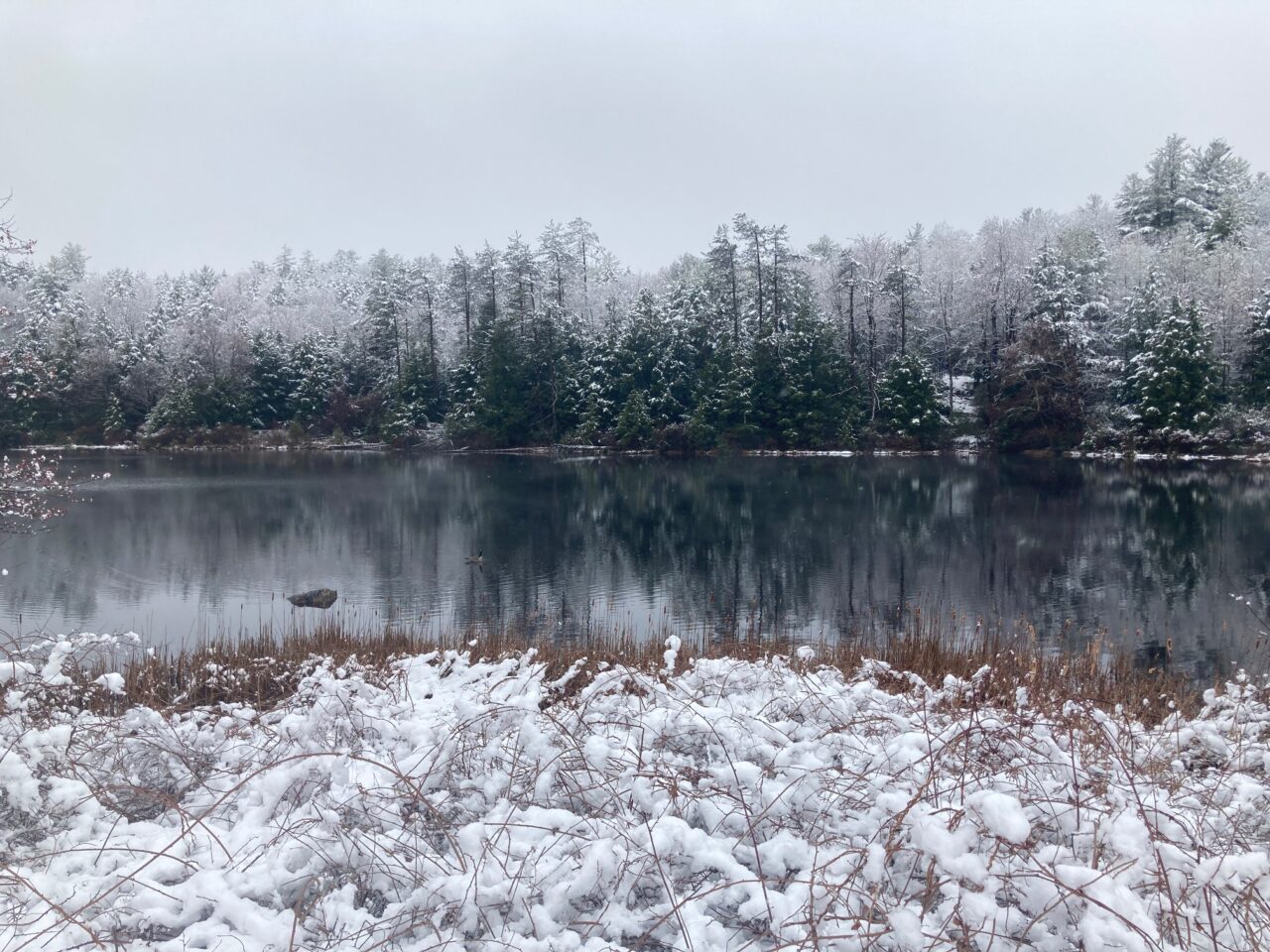
An accurate description of March’s weather this year would be that it was unremarkable. Last year it was warm, sunny and nice. If you like snow, however, last year was terrible because it was the least snowy March on record. This March was middle of the pack in just about every weather category. The month of March can have traits of both winter and spring, but this year it was stuck in between both without much of either. After finally icing over for the season around January 3-4, local ponds lost their ice around March 21-23. Comparing this to the last twenty years, this winter they iced over a little later than normal and went out a little earlier than normal. Thanks to our cold January and average cold February, ice depths during this season’s peak were thicker than in recent years.
March’s low temperature of 4 degrees was observed on March 4 and the high of 66 degrees was observed on March 18. One new record daily high temperature was set this month; the high of 57 on March 6 just surpassed 1935’s 56. There were two days with single digit lows and one day with a high temperature that topped 60 degrees. One interesting fact this month was that it was 8 degrees on the morning of March 5 and it was 57 on the afternoon of March 6. The month ended with three days with temperatures in the low teens. March is a fickle weather month. With an average monthly temperature of 33.6 degrees, it was 2.9 degrees above normal. This March came in as the nineteenth warmest March over the last 91 years. Norfolk’s warmest March was in 2012 with 41.8 degrees, the coldest was in 1960 with 21.2 degrees.
The total precipitation recorded for the month was 2.93 inches. This was 1.41 inches below normal, but not high ranking. The precipitation that fell was fairly evenly distributed throughout the month. There were no big rain or snow storms this month. Norfolk’s driest March was in 1981 with 0.64 inch, the wettest was in 1953 with 10.37 inches. Through the first quarter of 2022, the total precipitation amount was 10.50 inches, 1.49 inches below normal. For total precipitation, we are 2.73 inches above where we were last year at this time.
March’s snowfall total of 10.0 inches was 7.5 inches below normal. The largest storm snowfall was 4.8 inches from March 9. The peak snow depth during the month was 6 inches, occurring for just a few days early in the month. There was no snow on the ground for the entire second half of the month. Once again, not a good month for snow lovers. The least snowy March on record was last year (2021) with just 0.1 inch. The March with the most snowfall, also the snowiest month of any month on record for Norfolk, was in 1956 with 73.6 inches.
Through the first quarter of 2022, the total snowfall amount was 37.8 inches, 20.5 inches below normal. The 2021-2022 winter season (October-March) snowfall total through March was a meager 43.4 inches, a whopping 39.2 inches below normal. Through March, this winter ranks as the third least for snowfall over the last 91 years. The official winter season runs through May and Norfolk can see snowfall in April and even May, but it is looking like this winter will have a very high rank for least amount of snowfall. The season’s largest snowstorm, from late January 16 to early January 18, produced just 7.2 inches. All of these dismal snow figures are not what you would expect from the Icebox of Connecticut.
Through April 20, April was fairly normal for temperature, below normal for snowfall, but was over two inches above normal for total precipitation (mostly rain). The big weather story of April will likely be the strong thunderstorms that rolled into town during the afternoon of April 14. A strong cold front with thunder, lightning, hail, heavy rain and straight line winds, burst into town around 4:30 pm. The storm intensified right as it approached town. Norfolk was the only town in the state with considerable damage. There was considerable localized severe damage caused by multiple snapped and uprooted trees. Powerlines were knocked down and several roads, including Rt. 44 and Rt. 272, were closed while the damage was cleared and the lines were repaired. Most damage was near the center of town, making this one of the more impactful storms to hit town in quite some time.
February 2022 Weather
A Wet Month with Below Normal Snowfall
By Russell Russ
February was a wet month. There was some snowfall, but it was mostly rain and freezing rain for precipitation this month. It was not ideal for wintertime weather in Norfolk. Last February was a snow lover’s paradise with 35 inches of snowfall. That was not the case this February with not even 10 inches of snowfall and several days of rain and freezing rain.
The month’s low temperature of zero degrees was observed on February 6 and the high temperature of 59 degrees was observed on February 23. There were seven days this month with single digit temperatures and one day with zero degrees. There were no days with below zero temperatures. Two days tied record highs for daily temperatures. The high of 54 on February 17 tied the 2011 record and the 55 on February 22 tied the 2017 record. The average monthly temperature was 25.1 degrees, 2.9 degrees above normal. It was above normal for warmth, but not high ranking. The warmest February on record was in 2002 with 30.7 degrees. The coldest was in 1934 with 9.0 degrees, making that also the coldest month of any month as recorded at this weather station.
Total precipitation recorded for the month was 5.01 inches, 1.38 inches above normal. It was Norfolk’s tenth wettest February over the last 91 years. A majority of February’s precipitation was in the form of rain or freezing rain, with a small portion coming as snowfall. Fortunately, the freezing rain that Norfolk experienced was more of a nuisance than a major problem for roads, trees or powerlines. This winter’s weather patterns are just not forming in a way to produce much snow here in Norfolk, and really for much of the Northeast US, except maybe for eastern Massachusetts and northern New England. The record for most February total precipitation is 11.70 inches from 1981, the least amount is 0.60 inch from 1987. The 2022 calendar year (January and February) total precipitation amount of 7.57 inches was just 0.08 inch below normal.
February’s monthly snowfall total of 9.9 inches was 10.4 inches below normal. Even with below normal snowfall and above normal rainfall for the month, thanks to January’s snowfall and no real wildly high temperatures, there was a snow cover on the ground for twenty six of the month’s twenty eight days. Snow depths ranged from 12 inches to zero inches. This month ranked as Norfolk’s fifteenth least snowy February over the last 91 years. The record for most snowfall in February is 52.4 inches from 1969 and the least is 4.8 inches from 1998.
The 2022 calendar year snowfall total through February was 27.8 inches, 13.0 inches below normal. The snowfall total for this winter season (October through February) was just 33.4 inches, 31.7 inches below normal. Not a good statistic for the area’s snow loving crowd, from those that try to make a living from snow to those that just play in it.
March is often Norfolk’s transition month between winter and spring. It is a month that can have both winter and spring conditions and sometimes just winter or spring conditions. Through March 21, this March was leaning more spring-like with just a few flashes of wintertime (snow) trying to make a show. March was running 4 degrees warmer than normal with both snowfall and total precipitation being a little below normal. Last March was Norfolk’s least snowy March on record. This March, with just 9.6 inches through March 21, was already way better than last March, but it will not be changing our low ranking for seasonal snowfall very much. As of late March, this winter was holding onto the rank of third for least amount of seasonal snowfall. Norfolk certainly can see snow in April and even May. We shall see if our coming spring has any winter left in it before this season’s snowfall totals go in the record books.
January 2022 Weather
A Cold Start to the New Year
By Russell Russ
The year of 2021 was Norfolk’s eighth warmest year and December was the seventh warmest December on record. Winter season snowfall was considerably below normal through December. Would we skip winter this year or was winter just a little slow to appear? Based on January’s weather, it appears that winter was just a little slow to arrive for Norfolk this year. January 2021 had four days with low temperatures in the single digits and just one day below zero. In comparison, this January had seven days in the single digits and eight days with below zero temperatures. Yes, winter found its way back to Norfolk. At least in January it did.
January’s average temperature of 17.9 degrees was 3.0 degrees below normal. It was 5.0 degrees colder than January 2021 (22.9) and 10.0 degrees colder than January 2020 (27.9). These recorded temperatures are pretty amazing. Even with all the cold temperatures, there still were no days with daily record temperatures this month and this January only ranked as tied with 2005 as Norfolk’s 21st coldest January. Remember, January is supposed to be one of the year’s coldest months and in Norfolk’s past, there have been many cold ones. January’s high temperature of 48 degrees was on January 1 and the low of minus 9 degrees was on January 22. Norfolk’s warmest January on record was in 2002 with an average temperature of 31.7 degrees and the coldest was in 1982 with 11.7 degrees.
January’s total precipitation of 2.56 inches was 1.46 inches below normal. The wettest January occurred in 1979 with a total of 11.77 inches and the driest was in 1970 with just 0.74 inch. The monthly snowfall total of 17.9 inches was 2.6 inches below normal. Of January’s thirty-one days, there was at least 3 inches of snow on the ground for twenty five of them. Even with the month’s colder than normal temperatures, Norfolk still had a few days with rain and freezing rain. The largest storm snowfall total was 7.2 inches from January 16-17. Fortunately, even with some snow and freezing rain during the month, there were few widespread travel or power issues. The snowiest January occurred in 1987 with 50.5 inches. Coming in at second snowiest was January 2011 with 50.0 inches. The least snowy was in 1980 with just 2.6 inches.
Norfolk’s 2021-2022 (October-January) winter season snowfall total through January was just 23.5 inches, 21.3 inches below normal. As much as January gave it a good winter effort, October through December failed miserably in their attempts at winter weather. It will take a strong effort from February and March to bring Norfolk back to near normal for winter snowfall levels.
A look at February’s weather through two-thirds of the month showed that winter was still here. Not a snow lovers paradise, but it was winter. Temperatures were running just a little above normal with a few days reaching the upper forties and even one day in the mid-fifties, but there were also several days in the single digits. Temperature swings were the norm. Snowfall was considerably below normal with just under five inches recorded. Precipitation, however, was above normal. One storm alone on February 3-5 produced 2.29 inches. This precipitation was mostly in the undesirable form of rain and freezing rain. As is fairly common in Norfolk’s higher elevation, there was considerable tree and wire icing from this event. Surrounding towns did not get the icing, but many parts of Norfolk (including the center of town) were covered in a shimmering glaze of ice for a few days. There were some minor power and road issues, but fortunately it just produced a slew of pretty pictures instead of too much trouble.
A Yearly Summary for 2021
A Look Back at Norfolk’s 2021 Weather
By Russell Russ
Norfolk’s weather for 2021 was interesting. Isn’t the weather always interesting? What rightly first comes to mind when remembering 2021’s weather is how wet it was during the summer and fall. What also might come to mind is the relative lack of snowfall. Digging deeper, Norfolk residents might remember how lousy the weather was for some of our holidays. Weather for Memorial Day and Independence Day was cool and wet and not very summer-like. Labor Day was not that nice either, but at least it was not as gloomy as the others. Thanks to an overnight light coating of snow, Norfolk did just barely squeak out a white Christmas, but the snow was gone very soon after. To finish out the year, between Christmas and New Year’s, we saw several dreary days with fog, drizzle, rain and freezing rain.
Temperatures were above normal for most of 2021. Ten of twelve months came in as warmer than normal. Three months (August, October and December) were ranked in the top ten for warmth. There were eight days during the year that set new record daily high temperatures. There was one day that set a new record daily low temperature. The coldest day of the year was on January 29 with a low temperature of minus 2 degrees. That was the only day of 2021 with a below zero temperature. The warmest day of the year was on June 29 with a high of 91 degrees. Norfolk hit 90 degrees or above just two times during the year. It was 91 on June 29 and 90 on June 30. This is about average for Norfolk. It was quite cloudy and rainy for a good part of July through October, likely keeping temperatures lower than they might have been had there been a little more sunshine. With an average yearly mean temperature of 47.3 degrees, the year ended up being Norfolk’s 8th warmest over the last 90 years. The warmest year was in 2012 with 48.5 degrees and the coolest was in 1940 with 41.9 degrees.
Snowfall for the year was quite a bit below normal. The calendar year snowfall total of 59.1 inches ranked 2021 as Norfolk’s 10th least snowy year over the last 90 years. Seven of 2021’s eight “snow season months” were below normal for snowfall. Norfolk’s snowiest year was in 1956 with 175.1 inches and the least snowy was in 1998 with just 33.0 inches. The October 2020 – May 2021 winter season snowfall total was 77.6 inches. This was below normal, but not high ranking. Had it not been for February’s 35.0 inches, both the yearly and winter season snowfall totals would likely have been in the top three for least snowy. March, with just 0.1 inch of snowfall, was the least snowy March on record.
The yearly total precipitation amount of 60.00 inches was 7.47 inches above normal, ranking it as the 16th wettest year over the last 90 years. Seven months were above normal and five were below normal, but the months that were above were considerably above. The year started out dry and by the end of April the precipitation deficit was 5.63 inches. The deficit was 5.02 inches after June. Then came the rains. July with 13.05 inches was Norfolk’s wettest July on record. It was also the 8th wettest month of any month over the last 90 years. August through October were also above normal. At the close of October, the year’s surplus peaked at 11.24 inches. The weather then changed and November and December were below normal. We were flirting with top 10 for wettest year until the final two months of the year. Norfolk’s wettest year was in 2011 with 77.28 inches and the driest was in 1965 with 33.89 inches.
November and December 2021
A Slow Start For Wintertime Weather
By Russell Russ
The final two months of the year bring us closer to wintertime. This year there were glimpses of wintertime weather in November and December, but for the most part, winter held off until after the ball dropped on the New Year. What was very notable was the change to less precipitation during the final two months of the year. Our string of much wetter than normal months from July through October was broken. November and December were both well below normal for snowfall and total precipitation. December was high ranking for warmth. Most local ponds started icing over in late November into mid-December, but the ice then went in and out several times and most ponds were not fully iced by the end of December. November, the potential predictor month for winter, was colder and drier than normal. Could that mean this winter will be cold and dry? Time will tell.
November’s average temperature of 36.6 degrees was 0.5 degree below normal. It was over five degrees colder than November 2020. Temperatures ranged from a high of 63 to a low of 15 degrees. The high of 63 degrees on November 18 tied the 1963 record high for that date. Total precipitation for the month totaled 2.37 inches, 2.21 inches below normal. It was Norfolk’s 11th driest November over the last 90 years. Norfolk’s driest November was in 2012 with just 0.84 inch. There was just 1.5 inches of snowfall for the month, 5.1 inches below normal. The first flakes of the season came on November 14 and the first measurable snowfall came on November 26.
December’s average temperature of 32.3 degrees was 6.5 degrees above normal, ranking it as Norfolk’s 7th warmest December. Temperatures in December ranged from a high of 60 to a low of 13 degrees. There were three days with record daily high temperatures: December 11 with 59 (was 56 in 1979), December 16 with 60 (was 55 in 1982) and December 17 with 52 (was 50 in 1984). Norfolk’s warmest December was in 2015 with an average temperature of 39.5 degrees. With a monthly total precipitation amount of 3.01 degrees, it was 1.56 inches below normal. December’s monthly snowfall total of 4.1 inches was 12.7 inches below normal. Unlike last year, Norfolk did have a white Christmas this year, although with just one inch on the ground in the morning it just barely made it, and the snow was gone by the next morning. This December ranked as Norfolk’s 7th least snowy December over the last 90 years. Norfolk’s least snowy December on record was in 1943 with a monthly snowfall total of just 0.6 inch.

October 2021
Seventh Warmest October on Record
By Russell Russ
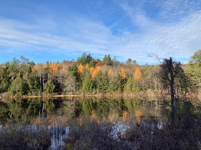
October was another above normal month for both temperature and precipitation. The fall foliage season this year, for the most part, was not all that fantastic. There was some colorful foliage, especially early in the season in the swampy areas, but with many maples having issues with the wet weather, this year will likely go down as poor in the foliage record books. Hard to say if it was a late season for foliage color due to the maples, but it probably was a week or so behind normal because of the extended warmth. As usual, under the impatient and watchful eye of fall cleanup crews and leaf raking homeowners, the oak trees were still hanging onto their leaves at month’s end.
The month’s high temperature of 74 degrees was observed on October 15 and the low of 30 was observed on October 29. The monthly mean temperature of 52.5 degrees was 4.7 degrees above normal, ranking it as Norfolk’s seventh warmest October over the last 90 years. Norfolk’s warmest October was in 2001 with 55.3 degrees. The coldest was in 1974 with an average temperature of 42.0 degrees. There were a few days with light frost in the usual lower elevation valley locations. The first days with widespread frost were October 24 and 29, quite a bit later than usual. Over the last 90 years, there have been only five days in October with temperatures that reached 80 degrees or above. Those dates are: Oct 5, 1941 (83), Oct 5, 2007 (80), Oct 6, 2007 (80), Oct 10, 1939 (82), and Oct 12, 1938 (81).
The total precipitation for the month was 6.04 inches, 1.68 inches above normal. It was not all that high ranking, but it was Norfolk’s nineteenth wettest October over the last 90 years. It was the fourth month in a row with above normal precipitation. Norfolk’s wettest October occurred in 1955 with 17.49 inches (also second wettest of any month). The driest October was in 1963 with just 0.63 inch (also the third driest of any month). There was no snowfall this October, technically making it 0.9 inch below normal. October’s record for monthly snowfall was the super impressive 23.8 inches recorded in October 2011.
Through October, the total precipitation amount for the year was 54.62 inches. This was 11.24 inches above normal through October. At the end of the month, this year’s total already surpassed Norfolk’s average annual amount by 2.09 inches. To add to this, this year’s total was a little over 20 inches more than last year’s total through October. Time will tell, but the year of 2021 is on track to be top ten for both precipitation and temperature.
It has been stated that November, and even more specifically, the first half of November, can sometimes predict what type of winter we will have. November this year definitely brought a change from our string of months with above normal temperatures and above normal precipitation. The first half of November this year was cold and dry. The period November 1-12 was the longest stretch of days all year without precipitation. The first snow (barely measurable) of the season came on November 14 and 15. Interestingly, the date of oak leaf drop this year was just about normal, starting around Veteran’s Day and mostly all down by mid-month. The oaks were right on schedule.

September 2021
Warm and Wet – Again
By Russell Russ
September was yet another non-typical weather month for Norfolk. It did not feel that warm or wet all month, but the final monthly totals told a different story. In just a period of about three days, remnants of a Gulf Coast landing hurricane and then three weeks later a strong cold front combined to produce a vast majority of the month’s rainfall. Without these two relatively short duration rain making events, September would have come in as one of Norfolk’s driest Septembers on record. It was a poor foliage season for the area’s sugar maples, a casualty of our wet summer and fall, but there was fall coloring and it began to be quite noticeable by the middle of the month. By the end of the month, local swamps were all showing off their beautiful classic red glory. It is debatable, but some say the foliage change this fall was a little later than usual.
September’s high temperature of 81 degrees was observed on September 15 and the low of 43 degrees was observed on September 29. The month’s average mean temperature was 61.5 degrees, 2.5 degrees above normal. This month was tied with 1946 and 1971 as Norfolk’s 11th warmest September. Norfolk’s warmest September was in 2015 with a mean temperature of 64.7 degrees. The coolest was in 1963 with 53.6 degrees. There were no daily temperature records set this month and there was no frost anywhere to be found in Connecticut. Last year the first frost came to some Norfolk locations by September 15, with the first widespread frost occurring on September 21. It is fairly normal for some parts of Norfolk to see a few frosts in September. This September was just too warm for that. It did extend the growing season though.
The month’s rainfall total was 8.80 inches, 4.13 inches above normal. Nearly 90% of September’s monthly rainfall came from two relatively short duration rain events. That seems wild, but it actually is not all that uncommon. This September came in as Norfolk’s 9th wettest September. Norfolk’s wettest September was in 1938 with 13.40 inches and the driest was in 2014 with just 1.16 inches.
Through September this year, the total yearly precipitation amount was 48.58 inches. This was 9.56 inches above normal through the third quarter of 2021. A very interesting fact is that after September of 2020 Norfolk’s precipitation total was just 29.18 inches. That was 9.96 inches below normal and 19.40 inches less than this year’s running total. Talk about a complete switch from one year to another. The year of 2020 ended up being Norfolk’s 18th driest year on record. With still three months to go in 2021, if our above average monthly precipitation continues to occur, Norfolk could be flirting with a Top Ten wet year.
In a preview of October’s weather, through October 21, it was much warmer than normal. It is very likely that this October will rank very high for warm Octobers. There were a few reports of very light frost in some lower elevation valley locations on October 7 and 19, but still no widespread frost and just a few days with that typical October chill in the air. Rainfall was about normal with most of the month’s current total of 2.71 inches coming during a rain event on October 3-5. Norfolk’s foliage season “number one” (maple and ash) was about over by October 21, with foliage season “number two” (oak and beech) yet to come. The peak day for foliage this year was hard to pinpoint. The forecast is for weather patterns to change during the final week of the month. Winter is (slowly) approaching.
